Previous What's New?
November 2025
Maine DEP's Lake Scorecard

The Maine Department of Environmental Protection (DEP) has developed a new lake scorecard for every lake in Maine. The scorecard summarizes many types of lake data into one color-coded graphic, based on current conditions or trends in the lake's health. The color is indicative of an overall condition assessment of each category: blue = good, yellow = fair, and red = poor. Grey indicates there is not enough data for an assessment.
To find a lake's scorecard, search for a lake, scroll down the lake's overview page and click on the scorecard image.
To learn more about the scorecard and to have the opportunity to ask the DEP questions, attend this webinar:
Understanding the New Maine DEP Lake Scorecard
Watch Explanatory Webinar
Questions? Email: MaineDEPLakeScorecard@Maine.gov
May 2025
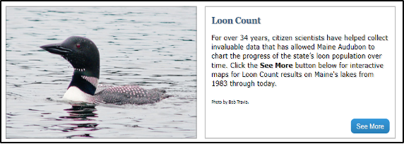
Check out Maine Audubon’s Loon Count Data
See the Loon Count Results
https://www.lakesofmaine.org/loons.html

Learn more about volunteering in the Maine Loon Count and get involved
https://maineaudubon.org/projects/loons/annual-loon-count/
Learn about the other Maine Audubon Loon Project
https://maineaudubon.org/projects/loons/
December 2024
2024 Cyanobacteria Aggregation Reports
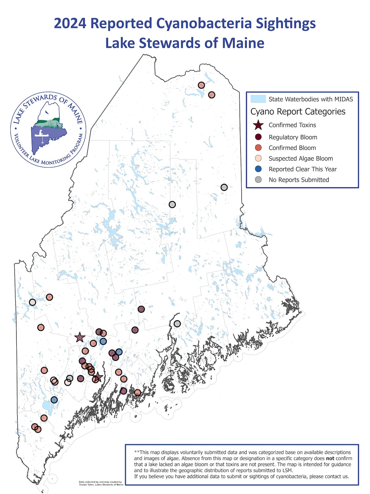
This map shows reports of cyanobacteria aggregations across Maine received by LSM and our partners during the 2024 field season. It also highlights some lakes that are of interest but we did not have any reports on in 2024. Built using ArcGIS software, this map serves as both a geographic snapshot and an awareness tool for communities near affected lakes.
Listing of Lakes:
| Lake | Town | County | Category | Toxins Detected |
| Androscoggin Lake | Leeds, Wayne | Androscoggin | Regulatory Bloom | |
| Annabessacook Pond | Monmouth, Winthrop | Kennebec | Confirmed Bloom | |
| Lake Arrowhead / Ossipee Flowage | Limerick, Waterboro | York | Confirmed Bloom | Non-detect |
| Brewer Lake | Bucksport, Holden, Orrington | Penobscot | No Reports Submitted | |
| China Lake | China, Vassalboro | Kennebec | Clear This Year | |
| Clary Lake | Jefferson, Whitefield | Lincoln | Confirmed Bloom | |
| Cobbossee Lake | Litchfield, Manchester, Monmouth, West Gardiner, Winthrop | Kennebec | Confirmed Bloom | |
| Cross Lake | T16 R5 WELS, T17 R5 WELS | Aroostook | Confirmed Bloom | |
| Damariscotta | Jefferson, Newcastle, Nobleboro | Lincoln | Confirmed Bloom | |
| Drews / Meduxnekeag Lake | Linneus, New Limerick, Oakfield | Aroostook | No Reports Submitted | |
| East Pond | Oakland, Smithfield | Somerset | Confirmed Bloom | |
| Echo Lake | Fayette, Mount Vernon, Readfield | Kennebec | Confirmed Bloom | |
| Ellis Pond | Byron, Roxbury | Oxford | Confirmed Bloom | |
| Hobbs Pond | Norway | Oxford | Confirmed Bloom | |
| Hogan | Oxford | Oxford | Confirmed Bloom | |
| Katahdin | T3 R8 WELS | Penobscot | No Reports Submitted | |
| Lake Auburn | Auburn | Androscoggin | No Reports Submitted | |
| Lone | Waterboro | York | Confirmed Bloom | Non-detect |
| Long Pond | Belgrade, Mount Vernon, Rome | Kennebec | Confirmed Bloom | |
| Madawaska | Westmanland, T16 R4 WELS | Aroostook | Confirmed Bloom | |
| Mooselookmeguntic / Cupsuptic Lake | Rangeley, Rangeley Plt, Adamstown Twp, Lower Cupsu | Franklin | Suspected Algae Bloom | |
| North Pond | Rome, Mercer, Smithfield | Kennebec | Regulatory Bloom | |
| Panther | Raymond | Cumberland | Clear This Year | |
| Paradise Pond | Damariscotta | Lincoln | Regulatory Bloom | |
| Pleasant Pond | Gardiner, Litchfield, West Gardiner, Richmond | Kennebec | Confirmed Bloom | Non-detect |
| Pleasant Pond | Gardiner, Litchfield, West Gardiner, Richmond | Kennebec | Confirmed Toxins | ~1ppb microcystin |
| Purgatory Pond | Litchfield | Kennebec | Confirmed Bloom | |
| Sabattus Pond | Greene, Wales, Sabattus | Androscoggin | Regulatory Bloom | |
| Saddleback | Dallas Plt | Franklin | Confirmed Bloom | |
| Salmon | Belgrade, Oakland | Kennebec | Clear This Year | |
| Salt Pond | Cushing, Friendship | Knox | Confirmed Bloom | |
| Sand Pond | Chesterville | Franklin | Confirmed Toxins | ~3ppb microcystin |
| Sebasticook Lake | Newport | Penobscot | Regulatory Bloom | |
| Taylor Pond | Auburn | Androscoggin | Suspected Algae Bloom | |
| Threemile Pond | China, Windsor | Kennebec | Regulatory Bloom | Non-detect |
| Unity Pond | Burnham, Troy, Unity | Waldo | Regulatory Bloom | |
| Watchic | Standish | Cumberland | Confirmed Bloom | |
| Webber | Vassalboro | Kennebec | Regulatory Bloom | Non-detect |
| Wilson | Monmouth, Wayne | Kennebec | Confirmed Bloom | Non-detect |
| Whitney Pond | Oxford | Oxford | Suspected Algae Bloom |
Help us monitor Maine’s lakes! Report cyanobacteria aggregations via email at steward@lakestewardsme.org or download the BloomWatch app which can be found on our website.
April 2023
Updated Loon Data on Lakes of Maine
Lakes of Maine has been updated with the Maine Audubon Loon Count Data. The Loon Count is an important and loved program and we are so happy to be a part of it. Find the results in the links below:
Lakes of Maine has been updated with the Maine Audubon Loon Count Data. The Loon Count is an important and loved program and we are so happy to be a part of it. Find the results in the links below:
Loon Data Visualization: https://www.lakesofmaine.org/loons.html
Lakes of Maine home page: https://www.lakesofmaine.org/
Go to search for Your Lake > Select Your Lake > Select Lake Life > Select Loons
December 2022
A Half-Century of Maine Lakes Data!

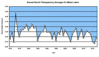
Last year, Scott Williams (long-time LSM Executive Director) wrote a short article about the early years of VLMP and the treasure trove of Secchi data produced by volunteers.
As we close out the 51st year of VLMP/LSM, it is worth taking another look at some stats on the lake water quality data collected over the years. Here are some tallies *:
- Secchi: 141,141 measurements from 1,066 lakes
- Phosphorus: 67,402 measurements from 936 lakes
- Temp/DO: 42,633 profiles from 944 lakes
- pH: 38,442 measurements from 874 lakes
- Conductivity: 31,733 measurements from 891 lakes
- Chlorophyll: 25,006 measurements from 908 lakes
- Color: 24,929 measurements from 910 lakes
- Alkalinity: 20,093 measurements from 887 lakes
Here are 3 interactive visualizations exploring these data:
(* These totals refer to data through 2018; as of the end of 2022, DEP had not released the more recent data for upload to this website. Totals include data from all lake stations and dates.)
September 2022
The Maine Lake Full of Sunken Steamboats

With an area of over 75 thousand acres, Moosehead is Maine’s largest lake (but not its deepest - that record is held by Sebago). Its size and its convoluted shape is why this lake has so many water quality monitoring stations. Daphne Merrill’s book “The Lakes of Maine” includes many tidbits of information (facts, legends) about Moosehead (link is HERE - scroll down to page 34).
The heyday of tourism at Moosehead was in the late 1800s and early 1900s. Many tens of steamboats catered to tourists during these years. Following the decline of the steamboat industry, many vessels were scuttled in the lake. BBC Travel has recently published an article about the steamboats of Moosehead and includes links to several videos showing the sunken vessels. These pieces make for interesting reading & watching!
August 2022
Maine Lakes - Fact & Legend
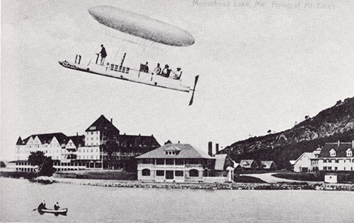
“Flying at Mt. Kineo”
Published 50 years ago, Daphne Merrill's book contains a fascinating assortment of facts, history & trivia about ME lakes. Although this tome is long out-of-print, we have been given permission to post a scanned version of the work. Click Read More to access the first 4 chapters. The rest of the book will be posted once scanning is complete.
June 2022
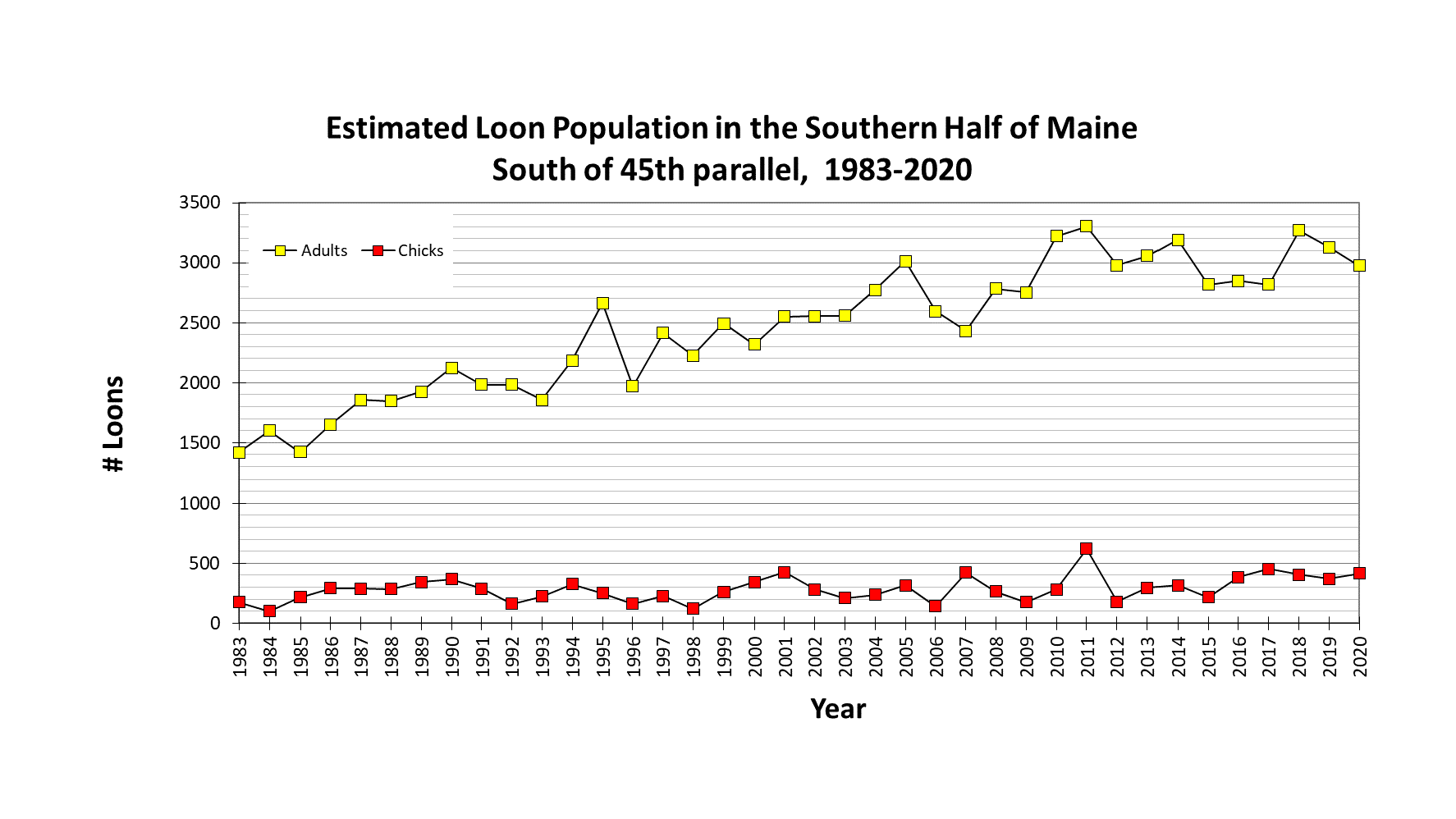
Loon Data Updated
In 2021, Maine Audubon’s Loon Survey covered 323 Maine lakes. The five lakes with the largest loon counts last year were: Great Pond (73 adults, 5 chicks); Great Moose Pond (54, 3); Damariscotta Lake (47, 6); Androscoggin Lake (46, 0); and Pushaw Lake (44, 2). (Of course, these five are all large lakes - larger lakes would be expected to have larger loon populations.)
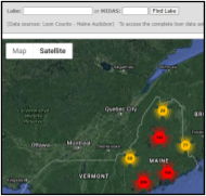
The easiest way to find loon data is to go to our Loon Count Portal (from our Homepage, click on the Conservation tab). Once there, enter a lake name (select from a list if there are multiple lakes with similar names). A map then displays - with the loon pin for the selected lake being larger than the other loon pins. Click on the pin to see the data. Explore other lakes in the vicinity by clicking on their pins.

To download the entire Loon Survey data set (all lakes, all years), go HERE.
June 2022
Updating the Data!
The mission statement of Lake Stewards of Maine (LSM) is:
“to protect Maine lakes and to promote lake stewardship through widespread citizen participation in the gathering and dissemination of credible scientific information pertaining to lake health.
LSM trains, certifies and provides technical support to hundreds of volunteers who monitor a wide range of indicators of water quality, assess watershed health and function, and screen lakes for invasive aquatic plants and animals. In addition to being the primary source of lake data in the State of Maine, LSM volunteers benefit their local lakes by playing key stewardship and leadership roles in their communities.”
To ensure that the collected data are credible, LSM and Maine DEP have a rigorous Quality Assurance (QA) program in place. The first step in the QA happens when LSM receives data sheets from volunteers. LSM staff complete a first review of the information and then forward the data to DEP. The DEP staff then conduct a detailed review of all the data and enter the information into the agency’s central database. Once this is complete, DEP sends the electronic data files to LSM which are then added to the database in LakesofMaine.org for display and retrieval by site users. This process generally occurs each year.
This process is time-consuming under the best of circumstances - and of course the pandemic has not helped. However, it is essential for ensuring that the information is credible, and that it can be used with confidence by lake scientists, community lake groups, research institutions, local, state, regional and national resource protections agencies, planning commissions, and others.
Currently DEP is completing QA on the block of 2019-2021 water quality data. We understand that this information will be sent to LSM soon. Once we have received the updated data from DEP and have uploaded this information into LakesofMaine.org, we will post an announcement in this space! It will get here!
February 2022
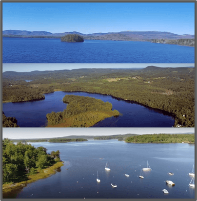
Categories of Maine Lakes for Better Assessments and Management
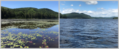
Jeremy Deeds (Maine DEP)
Consider the two lakes in the photographs above. The one on the left is smaller and shallower with abundant aquatic plant growth. The lake on the right is larger, deeper, and aquatic plants grow sparsely in isolated sections along its shore. Different as they are, these lakes share similarities, too. They are both found in largely undeveloped watersheds and have naturally vegetated shorelands. Since they are both in watersheds with minimal human-induced changes to the landscape, should we expect them to have similar water quality conditions? Now imagine that each lake had 100% of its shoreland area converted to residential house lots, manicured lawns, hundreds of septic tanks, and a network of dirt roads. How would the water quality in these lakes change? Would they both change in the same way, or would we expect these lakes to respond to those land use modifications differently?
Better Lake Assessments with Reference Data
Questions like these are at the heart of lake assessments that compare lake condition to an expected, or reference, condition. Reference lakes are those lakes with minimal human disturbance in the watershed. These lakes offer a representation of what the water quality conditions in lakes free from disturbance should be, thereby providing a benchmark for evaluating the condition of lakes that have been impacted by human activities. However, there are very few lakes remaining that have had minimal human influence, so finding suitable reference lakes for comparison studies can often be challenging. Identifying suitable reference lakes becomes even more difficult when attributes like size, depth and background nutrients vary so much across the state.
Changes to the land in a lake watershed will typically influence water quality in the lake. For example, watershed soil erosion and over-fertilization of land near lake shores and feeder streams can result in higher lake phosphorus and excess algae growth. But changes to the land are only part of the network of related factors that influence the water quality of lakes. These factors also include natural features of the landscape, such as geology and soil types, and features of the lake itself, such as lake size and depth. Natural features that help shape lake condition may be used to place lakes into categories that help to determine what the natural condition of a lake is expected to be. Using these categories, we can then examine how different types of lakes may change when their watersheds are modified by human activities.
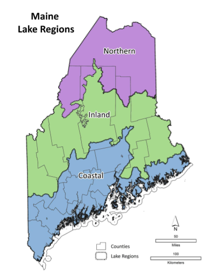
Categorizing Lakes
To discover which lakes in Maine might share natural features important for shaping lake condition, we examined possible groupings created by combinations of geographical areas, such as major river basins, biophysical regions, and ecoregions of different scales. We also tested these groupings with lake size and depth. We found that lakes grouped by regions defined by aggregated Level IV ecoregions had the most similar water quality. These Maine lake regions are shown in the map below. Lakes in each region are further divided into categories of deep lakes (maximum depth greater than 10 m, or 33 ft) and shallow lakes (maximum depth less than 10 m), creating a total of six “lake types” in Maine.
This is an excerpt of Jeremy’s full article. Read the full story HERE.
December 2021
Nearby Lake Navigation Map
Easy to use navigation!
You may have noticed a new feature on the Lakes of Maine website. On any lake’s overview page, you can now access nearby lakes by clicking either on the pink site markers on the map or by selecting one from the nearby lakes listed beneath the map.
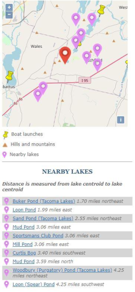
These nearby lakes are created by a radial distance measure from the center of each lake. You can scroll around the map, but only the immediate area around the lake will display the pink site markers. If you want to find a lake that is to the south and outside of the range of the site markers, you can click the most southerly pink site marker, opening up that lake’s overview page to reach its map and its nearby lakes.
If you don’t see a lake listed on the map that you think should be there (it is within the range of pink site markers but is not shown), feel free to send us a message about it. You can reach us at stewards@lakestewardsme.org or contact us by visiting www.lakestewardsofmaine.org.
September 2021
Maine Field Guide to
Aquatic Phenomena
Aquatic Phenomena

Every lake in Maine is a place of wonder & discovery!
Asiatic clam, Bellmouth Ramshorn, Bullfrog, Brazilian Elodea, Bryozoans, Eastern Elliptio, Fishfly, Gloeotrichia, Freshwater jellyfish, Lake balls, Langmuir currents, Rusty crayfish, Volvox, Water bear ...
These are a few of the more than 150 examples of flora, fauna and lake phenomena that you can find in Lake Stewards of Maine's (LSM) newly released Maine Field Guide. Stunning photos illustrate each item. The Guide also includes descriptions of attributes such as identifying characteristics, habitat, biology & ecology.
This is a crowd-sourced compendium! LSM encourages users of the Guide to further expand this resource by contributing additional items and observations.
Dive into this catalog and experience some of the wonders of Maine lakes!
The Guide is available as a mobile app and also as an on-line catalog.
April 2021
Maine Audubon Loon Count: 2020 results & plans for 2021

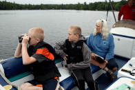
The Maine Loon Project has worked for more than three decades to assess the status and safeguard the future of Maine’s loon population. As part of this project, Maine Audubon works with over one thousand residents and partners statewide each year to conduct the Maine Annual Loon Count--a census of the Maine breeding loon population that has taken place on lakes and ponds throughout the state on the third Saturday of July every year for the last 37 years. And 2020 was no exception. Last year, 48 volunteer regional coordinators and 1,347 participants overcame challenges posed by the pandemic to safely survey 308 lakes and ponds across the state--sixteen more lakes than the previous year! The observations recorded by community scientist volunteers provide an annual “snapshot” of Maine’s loon population, which allows Maine Audubon to calculate an annual population estimate and track trends over time.
Click on the icons, below, to find out more about the loon surveys!
If you are interested in participating in the loon count, contact conserve@maineaudubon.org or click here for more information.

February 2021
Bird's Eye Views of Maine Lakes
We have collected some spectacular aerial videos of 26 Maine lakes, all captured by drones and published on Youtube or Facebook.
To view this collection, click on the image below.
November 2020
In the late summer of 2020, the invasive plant, variable water-milfoil (Myriophyllum heterophyllum) was found in Androscoggin Lake by volunteer Invasive Plant Patroller, Katherine Mahoney. In response, a coalition of local, regional and statewide partners leapt into action.
The coalition included 30 Mile River Watershed Association, Androscoggin Lake Improvement Corporation, Lake Stewards of Maine, and Department of Environmental Protection and a dedicated team of volunteer Invasive Plant Patrollers.
This video captures the majesty of the imperiled lake and the actions of those who are working to save it.
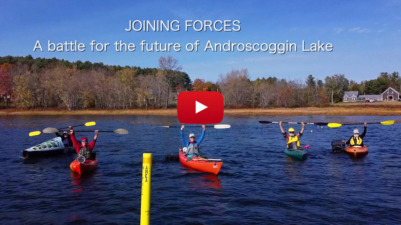
More information about Androscoggin Lake invasion can be found in the November 2020 lake of the month HERE.
August 2020:
The best-laid plans...
Big Lake, invasive milfoil & COVID-19
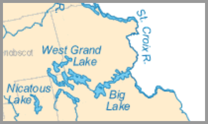
Big Lake is in the very heart of the Passamaquoddy Tribe’s ancestral homeland. Located in and around the town of Grand Lake Stream, near the border with New Brunswick, the lake is part of a sprawling and much larger - roughly 17,000 acre - system known for its remote, wilderness beauty and extraordinary fishing.
In October of last year, an urgent message from Joe Musante (a biologist with the Passamaquoddy Environmental Department) arrived at LSM headquarters. The invasive aquatic plant, Variable-leaf milfoil, had recently been observed for the first time in Big Lake.
The average depth of Big Lake is only 12 feet. This means that the littoral zone extends far out from shore along much of the lake’s 70-plus miles of shoreline. In addition to the vast shallows, the lake is rich in tributaries, coves and islands (28 islands to be exact!), all of which further increases the potential for invasive plants to move about unseen, while steadily gaining ground.
Given the pristine nature of this aquatic wilderness, intensive planning soon started to conduct a major invasive plant survey of the lake this summer. This would involve the Passamaquoddy Tribe, the Downeast Lakes Land Trust, IPP volunteers and, of course, LSM... However, Covid-19 has thrown a wrench into these plans and the planned mobilization of LSM-led volunteers to conduct a complete level-3 survey of Big Lake was postponed. Warning buoys have been placed in Clifford Bay to help boaters steer clear of known infested areas.
This summer for the first time, Downeast Lakes Land Trust staff have been conducting Courtesy Boat Inspections at Big Lake's primary public boat landing. In addition to inspecting boats launching into and leaving the lake, the CBIs are helping to educate boaters to the threat of aquatic invaders and what boaters can do to help prevent their spread.
This August, experienced solo adventurer and certified LSM Invasive Plant Patroller, Lucy Leaf, took it upon herself to travel alone to the Downeast Lakes Region to conduct screening surveys of some of Big Lake's surrounding waterbodies. (To be clear, working alone on the water is not EVER recommended by LSM, but Lucy was determined and we are very grateful for her efforts.) As a result of Lucy's work, small patches of variable-leaf milfoil have now been confirmed in downstream Lewey Lake and Long Lake. The spread of the infestation to downstream waters is very bad news indeed, but by finding these (possible) pioneer colonies early, Lucy has provided the Big Lake community with a window of opportunity to remove these new colonies before they become well established, so that the larger infestation may be contained.
DEP staff, working with local stakeholders will be conducting a major survey of Long Lake this September to get a better handle on the full extent of the infestation in Long Lake itself, in preparation for directing some targeted control operations later this fall. A group of property owners on Big Lake is also now organizing to help address the threat at the local level. LSM will contribute to this goal by providing a special online training in September, focused on the identification of variable watermilfoil and its common native lookalikes, to help broaden the local engagement in this effort to the widest extent possible.