Previous Featured Lakes
July 2023: East Lake (Hancock County)
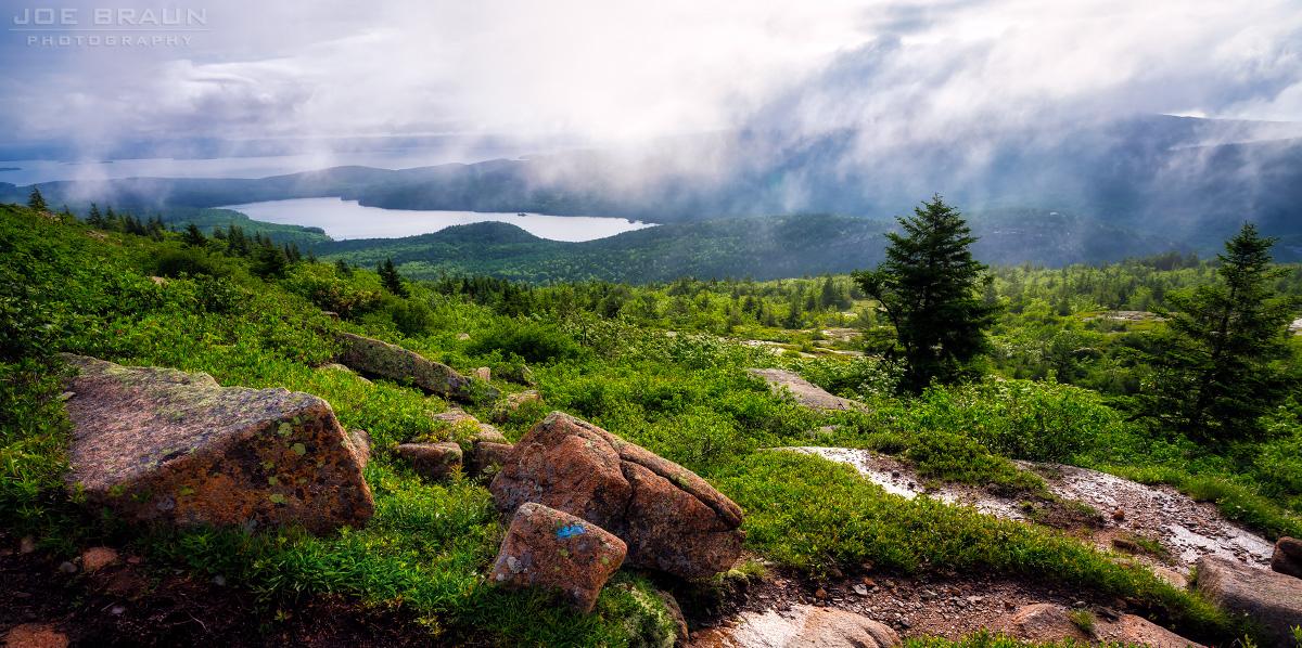
Image Credit: Joe Braun Photography (used with permission)
Of the 9 Great Ponds located wholly within Acadia National Park (ANP), Eagle Lake is the largest - 466 acres, with a maximum depth of 110 feet. (Long Pond, which borders ANP, is the largest lake on Mount Desert Island, and is approximately twice the size of Eagle Lake in terms of surface area.) One of the most visited carriage roads in ANP circles Eagle Lake.
Secchi data are available from the early 1980s, annual averages ranging from 8.7m to 12.8m (28-42 ft). A summary of water quality parameters is here. Eagle Lake is the water supply for Bar Harbor.

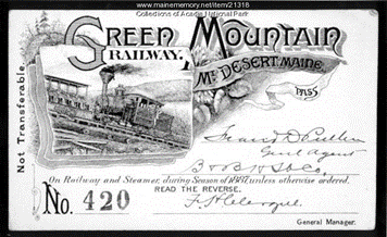
Eagle Lake has an interesting claim to fame. In the late 1800s, a Brewer entrepreneur, son of a French immigrant father and a mother with deep ties to Maine, decided that the growing number of tourists visiting the Bar Harbor area needed a convenient way to get to the top of Green Mountain (as Cadillac was known in those days). Francis Hector Clergue formed the Green Mountain Railway Company in 1882 with a capital of $90,000. The cog railway opened in 1883 and ran for 1.2 miles; it followed a design pioneered at Mount Washington. Passengers were taken by carriage from Bar Harbor to Eagle Lake. Here they boarded the steam ferry Wauwinet which transported them to the railway terminus on the other side of the lake. The enterprise’s most successful season was in 1886, with approximately 8000 passengers. A hotel was built at the summit to host visitors. It burned to the ground the year after construction but was replaced by another structure. However, construction of a road to the Green Mountain summit led to a decline in riders and in 1893 the company’s assets were sold off.
More information about the Green Mountain Railway is here and here. To learn more about the water quality, fish and plants of Eagle Lake, go here.
May 2023: Harriman Pond (Hancock County)
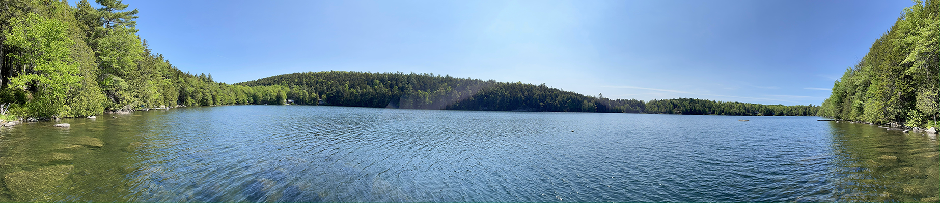
Image Credit: Sarah Nelson
Thanks to Sarah Nelson for contributing this article!
Harriman Pond - Bringing a community together
Harriman Pond is a small (41 acre), deep (over 75 feet), clear (average Secchi 7.74 m since 2019) lake in Hancock County that is nestled in a tiny watershed in the hills around Dedham. It is on Maine DEP’s Threatened Lakes Priority List due to its outstanding water quality combined with potential for development. The pond is also a headwater for Branch Lake in Ellsworth.
Like so many other lakes in Maine in the last several years, many properties have changed hands: either intergenerational within families, or sold to people new to the lake and area. Some property owners have been on the lake for generations – one family recently shared the story of how their grandfather was the first to buy land on the lake, and their camp was the first one built. One resident has done the annual loon count for over three decades; one new camp owner was LSM certified and started monitoring Secchi and Total P in 2019.
What they all have in common is the lake: it is clear, quiet, and small enough that all of the neighbors on the lake can be seen from your dock. Home and camp owners were invited to a first-ever gathering in 2022, where food, stories, and information were shared. Part of the reason for the gathering was to start talking about establishing a lake association.
Though not yet developed, members of the community have been following the steps outlined by Maine Lakes, including producing an annual newsletter. In 2021, Harriman Pond convened a team of volunteers to join the Branch Lake Watershed Association in a watershed survey and subsequent 319 grant, which was funded for activities beginning in 2023. This support comes at a critical time, when sharing information about best practices for living in the shoreland zone can help new lakefront landowners learn how to keep the lake clear and clean.
Watch drone footage of Harriman Pond HERE.

April 2023: Long Lake (Aroostook County)
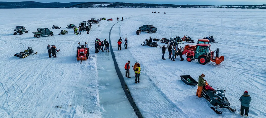
Image Credit: Aroostook Unmanned Aerial Services
Long Lake - A world record in ice
Maine is a big state and the conditions on lakes vary widely from North to South. As some lakes in the southern part of the state were reporting ice-out to us at Lake Stewards of Maine, the folks up in Saint Agatha were engaged in an international competition to make the world’s largest ice carousel. The three major players in this drama have been Maine, Minnesota, and Finland. “Finland took the most recent record in February [of 2023] with a disc measuring 1,692 feet in diameter. Janne Kapylehto carved the new record-setting disc on a remote lake in Lappajarvi, about a five-hour drive from Helsinki.” reported Jessica Potila with the Bangor Daily News.
However, on April 1st, 2023, Long Lake, located in northern Maine near the Canadian border, managed to pull off a new world record with an ice carousel measuring 1,776 feet in diameter. This feat was only made possible because of the 27+ inches thick ice that covered Long Lake that week. The ice at that thickness allowed for people to stand on it, attach outboard motors to it, drive trucks across it and the disc itself weighed somewhere on the order of 289,000,000 pounds.
This event was a wonderful community gathering. The group that headed this effort is called the Northern Maine Ice Busters, but many people who were not involved in the ice busting came out to support and celebrate with them. Even rival and former record holder Chuck Zwilling from Minnesota came and participated, helping cut ice to ensure Maine made it in the record books again. Lakes often offer people throughout the state a shared resource and focus that creates a sense of community and creates lasting memories. You can read more about the event on the Northern Maine Ice Busters Facebook page or the Bangor Daily News website.
Long Lake is the most northerly and deepest lake in a chain of lakes that run southward from the Frenchville-Madawaska area and lie near the base of the Longfellow Mountain range in Maine. Long Lake covers 6,849 acres, has a mean depth of 48 feet, but has a maximum depth of 163 feet. Average Secchi transparency is 4.2 meters, which is comparable with other waterbodies in the state. More information about Long Lake can be found here.
March 2023: Sebago Lake
Image Credit: John Stetson
About Sebago Lake
- Sebago Lake is located in the towns of Casco, Naples, Raymond, Sebago, Standish and Windham. It is the deepest and second-largest lake in Maine at 96.3 meters (316 feet) and 12,137 hectares (29,992 acres), respectively. The perimeter of Sebago -- 158 kilometers (98.2 miles) -- is substantially developed and about 90% of the watershed is privately owned. Despite this, significant eutrophication (caused primarily by phosphorus runoff) has been limited. This is vitally important as it is the primary water supply for the Portland Water District (PWD) which serves nearly 15% of Maine’s population. The reason for the limited eutrophication is due to the large and heavily-forested nature of the watershed and the fantastic work of PWD, Sebago Clean Waters, and many lake stewards. Two other factors that may play a role are that areas of its watershed -- notably the Long Lake region -- are naturally high in aluminum and are at greater elevation. Generally, higher elevations have less marine-derived clay soils which are typically high in phosphorus. A last note, the oldest recorded ice-out, taken in 1807 CE, comes from Sebago.
- The state of ice coverage on Maine lakes has become an increasingly prominent concern. It appears, based on ice-out data, that over the past 100 years there has been a substantial shift towards earlier ice-outs. This means it is likely that ice is covering lakes for less of the year. Extended periods of ice cover is one of the reasons why Maine has such high quality lakes compared to many other parts of the United States. Blooms of cyanobacteria and algae, and certain invasive species are all tempered or prevented from establishing due to the long, cold winters.
To discuss ice further we need to understand the terminology and complications of monitoring it. Both ice-in and ice-out are localized events defined by the observers. At Lake Stewards of Maine (LSM), we have provided some guidelines that individuals or lake associations can use. However, if there are historical observations, the observers should maintain that same criteria for determining these events. The consistency is vitally important to pick up on changes over time.
The monitoring by our citizen scientist network remains a critical component for understanding our lakes. In the mid-2000s, using data, including that collected by LSM volunteers, USGS Hydrologist Glenn Hodgkins was able to determine that the duration of ice cover for a number of New England lakes has been diminishing over the past century. This same conclusion has been arrived at by Lloyd Irland, PhD. This past summer LSM hosted Dr. Irland as a part of our summer webinar series. A recording of the session, Lake Ice Regimes: Some Baffling Trends and Challenges for Citizen Science, can be found HERE.

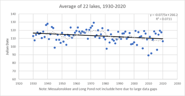
Charts by Lloyd C. Irland, from research now being prepared for publication.
Both ice-in and ice-out are really proxies for climate change and variations between seasons. The charts of average ice-out dates (above) show the movement towards an earlier ice-out, indicated by the negative slope of these two trend lines. One of the important take-aways is that there is significant variation between the years and even decades. It is only with long-term data sets that trends can be identified. Ice-out has a more robust historical record in many communities -- this may be due to the celebratory nature of warming weather and the autumn harvests and preparing for the colder months ahead. Although ice-in data is patchy and does not have as long a history as ice-out data, what is available indicates ice-in dates are becoming later. This double-sided attack -- later icing over in the fall and earlier retreat of ice in the spring -- is another troubling indicator of climate change and a warming Maine, more prone to algae blooms and invasive organisms.
If you’re interested in getting involved in ice data collection please check out the information available on our website and contact us HERE.
Learn more about Sebago Lake HERE or check out conservation areas near it HERE

December 2022: Long Pond (Kennebec County)

About Long Pond
There are 27 “Long Ponds” in Maine (and 6 “Long Lakes”). One of these is located in the Belgrade chain of lakes (it is fourth in the chain sequence).
Long Pond (Belgrade, Mt. Vernon, Rome) is a 2,557-acre lake, divided into 2 distinct basins. The “deep hole” (106 ft / 32 m) is in the southern basin.
This lake has 20 fish species, including the invasive northern pike (Esox lucius), as well as both black basses.
The Kennebec Highlands (ME Bureau of Parks & Lands) lie to the west of the upper basin, while the Belgrade Regional Conservation Alliance manages lands along the southern basin (CLICK HERE for map)
Water clarity has been measured in this lake since 1970; the overall average Secchi depth during this period is 6.3 m (21 ft) - a value which is in the mid-range of surveyed Maine lakes.
Discover more about Long Pond HERE.
October 2022: Hogan & Whitney Ponds (Oxford County)

Thanks to Scott Williams for contributing this article!
Hogan & Whitney Ponds - Near but dissimilar neighbors
Viewed from a drone or satellite image, one might expect that Hogan and Whitney Ponds, situated in the western foothills of Maine, would be as alike as “two peas in a pod”. As LSM certified lake monitor, Bruce Wilson’s, excellent photos show, the two lakes appear to be nearly identical in shape and surface area (178 and 167 acres respectively), as well as volume. The mean (average) depth of Hogan is 15 feet, and Whitney is 14 feet.
The two lakes are separated by a relatively narrow ridge of gravel and sediment, deposited several thousand years ago by meltwater from the retreating glacier. This “esker” between them is as little as ~40 feet wide. It is even possible at the narrowest point on the esker, which rises up between Hogan and Whitney approximately 25 feet, to stand in the middle and cast a stone into the water of either lake.
The outflow areas at the northerly end of the lakes join together to form a broad, shallow stream that provides extensive and diverse aquatic and riparian habitat for macrophytes, fish, amphibians, and waterfowl. The joined streams eventually flow into the Little Androscoggin River.
However, despite their proximity, similar shape, area, and depth, the two lakes are distinctly unique. That is primarily due to significant differences in their watersheds. The Whitney Pond watershed encompasses an area of ~1.1 square miles, compared to the ~3.8 square mile watershed for Hogan Pond. Hogan Pond flushes on the average 5.24 times/year, whereas Whitney only flushes 0.68 times/year.
The primary tributary to Hogan Pond (clearly visible on Google Earth) drains an extensively boggy area which extends to the outlet of Bog Pond in the town of Poland, so named because it is situated in an extensively wet, peaty watershed. Drainage from these boggy areas is very rich in humic acids and dissolved organic carbon – imparting a characteristic appearance to the water that is sometimes referred to as the “root beer effect”. Lakes that have moderate concentrations of natural color (> 25 Standard Platinum Cobalt Units) typically function differently than those with low color levels, and are referred to as “dystrophic”. Elevated concentrations of humic acids negatively influence lake water clarity/transparency, resulting in shallower Secchi disc readings. The typical dynamic relationships between the primary trophic state indicators (transparency, total phosphorus and chlorophyll) in lakes break down in dystrophic lakes.
The Whitney Pond watershed is much smaller and far less bog-like than Hogan Pond. Although the values for the primary indicators of water quality are relatively similar for the two lakes, the natural color level in Whitney is relatively low (average 13 SPU), compared to that of Hogan (29 SPU). Dystrophic lakes typically have lower planktonic algae and rooted aquatic plant growth, as a result of light attenuation in the water column due to the high concentration of color.
Several decades ago. (prior to Maine’s Shoreland Zoning ordinance came into being) the land area of the esker between Hogan and Whitney Ponds was subdivided. The unique formation between the two lakes (and resulting views) attracted numerous buyers who constructed summer cottages along the steep, and easily erodible slopes on each side. An access road was created along the center of the esker. Over time, the lack of electric service, poorly suited soils (and space) for septic systems, and the difficulty of stabilizing the steep eroding soils resulted in a number of the structures becoming abandoned and derelict. But the paucity of available lake shorefront property in recent years has sparked a renewed interest in the area.

August 2022: Tumbledown Pond (Franklin County)

Thanks to Sarah Nelson & Amanda Gavin for contributing this article!
Tumbledown Pond – One of Maine’s High-Elevation Lakes
Tumbledown Pond sits at 818 meters (~2700 feet) elevation, just below the peaks of Tumbledown and Little Jackson Mountains. A popular, but challenging, hike on public lands leads to the pond, but it serves as more than an incredible viewpoint—Tumbledown Pond has been part of long-term research that began in the 1980s and provided early evidence of acidification in Maine’s lakes and ponds. A set of High-Elevation Lakes in Maine (HELM) lakes have been sampled most years since 1986, some years by helicopter, and some years on foot, or even skis. Because of the long-term monitoring at these lakes and others in the US EPA’s Long-Term Monitoring network, we have been able to see that the sulfur pollution that largely causes acid rain in the northeast has declined dramatically. The Clean Air Act Amendments reduced sulfur coming from coal-burning power plants and other sources by about 90% since 1990. As a direct result of policy changes, sulfur in HELM lakes has also drastically reduced. This is a big success story – when we regulate pollutants, we can see changes in the environment and improvements in water quality.
Even with the success of the Clean Air Act Amendments, Tumbledown Pond, and other HELM lakes, are not out of the woods. Climate change in New England has led to warmer and wetter conditions, milder winters with less persistent ice cover, and an increase in extreme weather events. The HELM lakes that we continue to sample were the sentinels for acid rain, and we think they quickly respond to the influence of climate change as well. Not unlike the canary in the coal mine, the chemistry and biology of these ponds respond to increases in air temperature and precipitation and can help scientists make predictions about the severity of climate change and how it will impact other ecosystems. For example, dissolved organic carbon (DOC), which imparts a tea-colored stain to freshwaters, increased in most of the HELM lakes since the 1980s and is linked to warmer and wetter conditions and recovery from acidification.
Combining Maine’s HELM lakes with those in the White and Green Mountains, the Adirondacks, and the Berkshires, recent research showed that the DOC increase is happening across the Northeast, and has potential to influence the base of the foodwebs in these unique ponds. In addition to monitoring the chemistry of these ponds, researchers have been studying how water temperature, thermal stratification, and ice cover is changing in HELM lakes by deploying sensors to record temperature throughout the water column for the past ten years. This will provide more insight into the sentinel response of mountain ponds to climate change.
Mountain ponds, like Tumbledown, are charismatic staples of the Maine landscape that are beloved by Maine’s most seasoned adventurers and a great jumping off point for those new to exploring the freshwater wonders of Maine. For all visitors, practicing leave no trace principles while exploring lakes will help protect the lakes, along with the plants and animals that live within the watershed, for generations to come.
June 2022: Lloyd Pond (Piscataquis County)
Thanks to Sarah Nelson for assisting with this article!
Lloyd Pond - a remote pond in the Maine woods
Located just off of the Appalachian trail, 2-acre Lloyd Pond is one of many remote waterbodies deep within the Maine Woods. It lies just north of Long Pond (see map below) and flows into the West Branch of the Pleasant River. Brook trout and Golden shiner have been documented from Lloyd Pond. However, for many of these remote ponds and lakes, we know little (often nothing) about their water quality and biology.
In 2021, the Appalachian Mountain Club (AMC), with funding from the Maine Outdoor Heritage Fund and in partnership with LSM, started a project to learn more about these remote ponds in the Maine Woods. AMC’s Maine Woods Initiative property, established in 2003 and now including the Pleasant River Headwaters Forest, is ~100,000 acres owned and managed by AMC as an ecoreserve, recreational facilities & trails, and sustainable forestry operations.
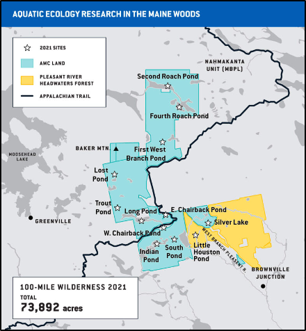
AMC ecologist Michael Macalus wrote about one of his recent forays to explore 11 ponds located deep within the 100-Mile Wilderness. Quoting Michael…”Many of the bodies of water in the Maine Woods hold a very unique and special attribute: they have experienced little to no human influence. This is quite rare, especially for the forests of the northeastern United States. The data I am collecting will allow us to begin to understand the “natural” conditions of lakes like these remote lakes, which serve as indicators—canaries in the coal mine—for other lakes in Maine, free from significant human impact. What make these data so special is that most lakes globally have been influenced one way or the other by boaters, frequent fishermen, beaches, historical or modern damming, development, and introduced species….”
READ Michael’s full article HERE!. (It’s billed as a “5-minute read” and is definitely worth it!)

May 2022: West Harbor Pond (Lincoln County)
Thanks to Merritt Blakeslee for contributing this article!
West Harbor Pond - Siphoning out the salt-water
West Harbor Pond in Boothbay Harbor is not your ordinary Maine lake. It came into being in 1880 when an entrepreneur dammed the mouth of Campbell’s Cove, a tidal saltwater estuary of Boothbay Harbor, for use as an ice pond. To render the impounded water suitable for making natural ice, a 10-inch cast-iron siphon was installed to evacuate the saltwater.
Normal freshwater lakes experience seasonal turnover that reoxygenates the deoxygenated water below the thermocline, ensuring the health of the aquatic environment. Until recently, however, West Harbor Pond did not experience this turnover because it had never been completely free of saltwater.

Route 27 causeway at lower end of West Harbor Pond with 1880 siphon (red) and 2018 replacement siphon (orange)
West Harbor Pond consists of a lower basin with a maximum depth of 25’ and an upper basin with a maximum depth of 37’, divided by a ridge with a depth of 18’. Because the intake of the 1880 siphon reached only to a depth of about 15’, the saltwater below that depth was not removed. This saltwater, being denser than the freshwater that the Pond receives from its tributaries, accumulates at the bottom, where its greater density prevented seasonal turnover and reoxygenation of the Pond. Thus, even during the period when the 1880 siphon was operating, the water below the 15-foot level remained entirely deoxygenated. Moreover, the Pond receives regular infusions of saltwater, which floods into the Pond in large quantities during king tides when the water from the inner harbor overtops the small dam in the box culvert.
In 2008, the 1880 siphon fractured, and thereafter the water in the upper level of the Pond began to deteriorate, with rising salinity and decreasing oxygen. In 2013, the West Harbor Pond Watershed Association, formed in 2009 with the mission of protecting and preserving the Pond, made the connection between this deterioration and the broken siphon and began testing the water column for salinity and dissolved oxygen. Their testing showed that below 15’ the Pond was a dead zone, its water highly saline, completely deoxygenated, and permeated with hydrogen sulfide, the natural product of vegetative decay in an anoxic environment. And the WHPWA feared that, with the failure of the 1880 siphon, the interface between the oxygenated and deoxygenated water was gradually rising.
The Association appealed to the state and municipal governments to repair the 1880 siphon, but to no avail. The State argued that it did not own the siphon – even though it ran through the dam that supported State Route 27 – and had no responsibility for repairing it. The Town argued that, because the Pond has no public beach or boat launch, it would be improper to devote public monies to what was, in its view, a private community.
In 2016, the Boothbay Region Water District generously offered to donate used six-inch high-density polyethylene water pipe, and the labor to fuse it, for use in the construction of a replacement siphon, provided that the WHPWA hire an engineering firm to draw up plans for the new siphon. The next year the WHPWA, with the support of the Town of Boothbay Harbor, received a Coastal Communities grant from the Maine Coastal Program of the Department of Agriculture to cover the engineering costs. In 2018, with the plans and permits in hand, the WHPWA launched a fund-raising campaign that netted over $60,000 in private donations from the Boothbay community in a matter of three months to replace the broken siphon.
The replacement siphon was installed in the winter of 2018-2019. Its intake is located at a depth of 25’, the deepest point of the lower basin. A page describing the five-year effort to replace the broken siphon can be found on the Pond Association's website at https://www.westharborpond.org/the-siphon-1. This page also contains a photo-essay titled “Green Dye on the Water” chronicling the siphon’s installation (last item on webpage).
This is an excerpt from Merritt Blakeslee’s article on West Harbor Pond.
READ the full story & see more photos of this pond HERE!.

March 2022: Sargent Mountain Pond (Hancock County)
Image credit: Joe Braun Photography
Thanks to Steve Norton & George Jacobson for contributing this article!
Sargent Mountain Pond - 16,000 years of history
Sargent Mountain Pond’s (SMP) area is about 2 acres, with a 3-to-4-acre watershed. Although small, it does have a MIDAS number (8473!). Located at 44.334°N, -68.270°W, 1,100 feet asl, it lies within Acadia National Park, a 0.65-mile walk south from Sargent Mountain. It is easily reached on foot with a 1.5-hour uphill walk from Route 198. The trails are well marked. The watershed contains only foot trails, with no roads or development, and it was not burned in the great fire of 1947. About 20% of the watershed is exposed bedrock. Vegetation is dominantly shrubs (including blueberries in August) with stunted red spruce, balsam fir, and birch. Currently, the lake is about 15 feet deep.
In March of 2007, led by co-author Jacobson (he also did pollen analysis), we retrieved a core of sediment, 17.4 feet deep, through 30 inches of ice. Thus, the lake originally was 32 feet deep (current 15 + 17 feet of sediment). Using carbon-14 dating, we established that the lake exceeded 15,700 years in age. SMP was likely Maine’s first post-glacial lake. It provided the longest record of lake sedimentation in Maine. The core was sliced into 0.8 inch thick cross-sections, each of which represented approximately 62 years. We analyzed each slice for five specific extractions of aluminum (Al), calcium (Ca), iron (Fe), and phosphorus (P) to answer questions about suspected relationships among the four elements. (You are carrying out an extraction when you use hot water to make tea and coffee. We use more rigorous extractions, but the concept is the same.) Questions we address here include: (1) Did Al play a major control on bioavailability of P? (2) When did this relationship start, and why? (3) Was the supply of P a limiting factor? We also analyzed pollen, in a more limited sample set, to reconstruct watershed vegetation and thus climate, and diatoms to reconstruct water quality - alkalinity, pH, and P. We analyzed the 16 rare earth elements (REEs), whose chemical behavior is similar to that of Al. Finally, we analyzed two atmospheric pollutants of interest (mercury [Hg] and lead [Pb], and Pb isotopes) to compare with earlier work on short cores (200+ years of record) and the 17.4 foot core. For those of you who enjoy chemistry and a challenge, there is a more detailed overview of other components of the study available at the link below, with references.

The Al-Fe-P story is shown on the graph above. The scale for P (green) is 10 times the original value to clearly show the correspondence between the timing of the major increase for Al (blue) and P, starting about 11,500 before present (B.P.) peaking at 10,500 B.P. The local forests became established after 11,500 B.P.; forests produce organic debris (litter) and organic-rich soil. The dead organic material produces Dissolved Organic Matter (DOM) during decay, which colors the water brown. In the soil, DOM can dissolve Al(OH)3 and P associated with it. The DOM in runoff carries Al and P to the lake where the Al and P precipitate together and become sediment. The concentration of P in the lake water consequently declines. Iron (Fe, brown symbols on the graph) plays a very minor role in SMP, but not so in all Maine lakes. The more rapid decline of P than Al is because nearly all the P in the till and bedrock is in the mineral apatite (calcium phosphate), which is much more soluble than the abundant sources of Al and becomes depleted in soil during ≈ 10 thousand years. The P supply to the lake from apatite in soil is now nearly exhausted. Diatom species in the sediment indicate that SMP was initially eutrophic, but then over time became oligotrophic. Pollen relationships show the evolution of the watershed, from ice-covered, to tundra, to forested (and corresponding warming); evolution of runoff chemistry to the lake was from higher (8) to lower (5) pH, higher to lower alkalinity, higher Ca to lower Ca, and eutrophic to oligotrophic. These changes required time, the presence of vegetation, and a warmer climate than existed prior to 16,000 years ago. Many lakes in Maine have become oligotrophic through processes similar to those at SMP, which has served as an important natural laboratory for discovery. Shallow lakes with different bedrock and glacial deposits sometimes evolve more slowly and may never leave the initial eutrophic state with high pH and high alkalinity. But they do get shallower. Some lakes have become more eutrophic through time, particularly if they experienced pollution in the centuries after European settlement. Over-fertilization with P can overwhelm the natural defenses associated with the morphometry and sediment chemistry of shallow and deep lakes.
Deep lakes are less prone to eutrophy than shallow lakes, and many Maine lakes remain oligotrophic after 15,000 years. Natural recycling of P from shallow lake sediment is increased in lakes with longer retention time and warming water columns. Dissolved “inorganic Al” is toxic to fish and increases in concentration at lower pH – one of the notable issues of the acid rain era. Fortunately, dissolved DOM binds with Al, rendering it non-toxic; and DOM is increasing in many lakes in Maine. High concentrations of Al(OH)3 in sediment tend to inhibit eutrophication. The chemical interactions of Al are complex, but studies such as the one on Sargent Mountain Pond are gradually revealing the details. Stay tuned!
We thank the ANP staff, especially David Manski; faculty, staff, and students at the University of Maine; and the National Science Foundation for field, laboratory, and financial support.
This is an excerpted version of Norton & Jacobson’s full article on Sargent Mountain Pond. Read the longer story HERE!.

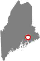
February 2022: Damariscotta Lake (Lincoln County)

Image credit: Bill Buchholz (Chickawaukie Ice Boat Club)
Thanks to Scott Williams for contributing this article!
About Damariscotta Lake
Damariscotta Lake is situated in the towns of Jefferson, Nobleboro and Newcastle, in Lincoln County. This large and diverse lake encompasses a surface area of nearly 4,700 acres, has a perimeter of 21.4 miles, and is among Maine’s best known and visited lakes, due in part to a popular State Park at the northern tip of the lake. There is a healthy and highly diverse warm- and cold-water fishery, which includes Atlantic Salmon, Lake, Brook and Brown Trout, Sea-Run Alewife, Largemouth Bass, American Eel and many additional documented species.
In her 1973 publication “The Lakes of Maine”, Daphne Merrill writes: “Damariscotta Lake was once called Mardarmeskunteag, or Madamescontee, meaning “young shad pool” or “plenty of alewives” which are called “madames” in Abenaki.
Damariscotta is one of relatively few Maine lakes that have multiple “true basins”, each of which functions as an independent, but hydrologically connected lake system. This phenomenon is due to two shallow and narrow areas in the lake that separate the three basins. Each of the basins has its own watershed, which when combined, encompass a total area of approximately 46 square miles. The large combined watershed areas include the additional towns of Washington and Somerville, situated to the north of the lake. Neither town has frontage on Damariscotta Lake, but the headwaters of several substantial tributary streams are situated in these two communities.
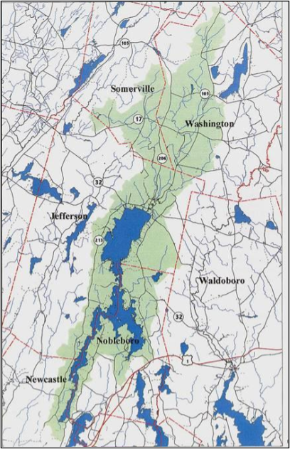
Damariscotta Lake watershed
The outlet for the three combined basins is situated at the southerly end of the South Arm, which flows into the Damariscotta River in Newcastle. Damariscotta Mills is the site of the annual Alewife festival, a community celebration of the return of Sea-Run Alewives to Damariscotta Lake through a historic fish ladder.
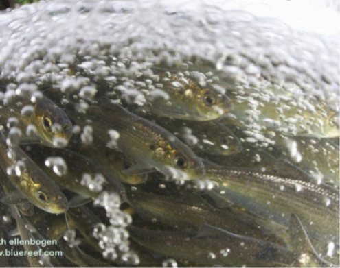
Alewives at the Damariscotta fish ladder. (Image from https://damariscottamills.org/alewife-festival/, 2/9/22)
This is an excerpt from Scott Williams’ full article on Damariscotta Lake. Read the complete story HERE.

December 2021: Georges Pond (Hancock County)
Image credit: Brian Friedmann
Thanks to John Eliasberg (Georges Pond Association) for contributing this article!
About Georges Pond
In Downeast Maine, north of Acadia and east of Ellsworth, lies the small town of Franklin. Founded in 1764 by Moses Butler and known for traditional Maine industries (blueberries, Christmas trees, granite, lumber, and shipbuilding), Franklin residents enjoy beautiful Taunton Bay, the 87-mile multi-use Down East Sunrise Trail and local hiking (e.g., Schoodic Mountain). Within Franklin lies Georges Pond, a 360-acre spring fed lake at 164-foot elevation and 45 feet deep. With such surrounding beauty, outsiders might consider Georges unremarkable, but to our Ponders, many of whom travel from around the country every summer and have been for generations, it is the most special place on Earth. One unusual feature of Georges is the shape of its basin, described by some as an inverted witch’s hat (it has a narrow deep hole). Some are also surprised that although the ocean lies only one mile south in Hog Bay, instead Georges’ water flows north and west more than 15 miles to empty via the Union River Bay.
Our story over the last 10 years is about a community successfully coming together in response to heartbreak. We had always enjoyed clear water and good fishing, and the need for an active lake association was not apparent (GPA had about 35 members generating $1,000 in dues). That changed in 2012 with our first algal bloom, which happened again in 2015, 2017 and 2018. We couldn’t swim, families didn’t visit, and people sold camps. We were angry and confused. We didn’t know what was wrong or how to fix it, and people offered many different opinions and solutions.
Linda Bacon (ME DEP) first helped us address our angry crowds, and then we turned to Jen Jespersen (EI) to learn how East Pond (Belgrade) had recently responded to similar conditions. We adapted a quote and perspective that, “The greatest threat to our Pond is the belief that someone else will save it.” We focused on a universal common goal – clean water, encouraged people to act immediately to improve their properties (Maine Lakes’ LakeSmart program), and asked the community for a year to collect data, formulate a plan and raise money.
The 2019 data indicated that Georges experienced a significant increase in phosphorus from internal loading (released from deep-water sediment during summer stratification and anoxia). This internal loading had presumably been happening for years. After considering many options (Ken Wagner, WRS), an Alum treatment was recommended to reduce the internal phosphorus loading. In May 2020 and 2021, we engaged HAB Aquatic Solutions to apply Alum and Lake Stewards of Maine to actively monitor water quality during treatment. Georges Pond thus became the 8th Maine lake to be alum-treated.
Our community is thrilled with the progress. Secchi readings have improved from a record low of 0.69m in 2018 to a record high of 7.55m in 2021. Total Phosphorus levels have dropped from a high of 27ppb in 2019 to a low of 9ppb in 2021. GPA membership has grown from 35 to 219 members. GPA has raised over $365,000. More than 50% of all property owners have completed LakeSmart surveys. Our community is successfully completing Phase 1 of an USEPA/MEDEP 319 Grant in 2021 and beginning another (Phase2) in 2022. And, LSM has trained more GPA citizen scientists. More on the alum treatment is HERE and images are HERE.
We are also pleased with how well our community has coalesced around our common good – clean water. We must continue to improve our property buffers, our gravel roads, and our septic systems. We are working more closely with our Town on improving public access and to promote Best Management Practices (BMPs) and adherence going forward. We believe that “The clarity of our lake will be a reflection of how well we take care of it.”
We are grateful for an outstanding community of willing experts and teachers (ME DEP, EI, WRS, LSM, HAB, and Maine Lakes). And, just as East Pond helped us, we are helping other lakes around Maine.
Find out more about Georges Pond HERE.
October 2021: Phillips Lake (Hancock County)
Image credit: Daniel Vanwart
About Phillips (Lucerne) Lake
If you stop at the Lucerne Inn (midway between Brewer and Ellsworth) you will get a very fine view of 859-acre Phillips Lake (especially during the leaf-off months). Originally called Fitts Pond, the lake’s current name comes from the family who founded and ran the original incarnation of the inn, Nathan Phillips and his brother or son John L. Phillips.
With a maximum depth of 98 feet, Phillips Lake ranks 84th by depth among Maine lakes; it is one-third as deep as Maine’s deepest lake, Sebago. The overall average Secchi depth is 8.2 meters, well towards the oligotrophic end of the transparency spectrum for lakes in our state.
The lake has two major outlets: Mill Stream in the northern end of the lake which connects to Alamoosook Lake, and a second outlet at the southwestern end of the lake, Mann Brook, which flows into Green Lake. In 2014, Phillips Lake was listed on Maine DEP’s Nonpoint Source Priority Watersheds List due to heavy development pressure in the watershed.
Steve Underwood has produced a great drone video of this lake.

(For drone videos of other Maine lakes, go HERE.)
Fishery: On Aug. 18, 1942, Gerald Cooper and John Fuller sampled Phillips Lake as part of their survey of Maine lakes. They noted that it was an “excellent trout or salmon water”. At that time, smallmouth bass had already been introduced - and this lake still supports a “pretty good smallmouth bass fishery”. According to IF&W, “anadromous alewives swim up the fishway in the outlet dam each spring. Although the magnitude of this run fluctuates considerably, it seems that diminished runs have been the rule recently, probably the result of numerous beaver dams on the lengthy outlet. An increase in smelt abundance has occurred coincident with the general decline in the number of alewives accessing the lake. This scenario has been observed over the years at a number of Downeast coastal lakes”.
Find out more about Phillips Lake HERE.
September 2021: Pleasant River Lake (Washington County)
Image credit: Pleasant River Lake Association
About Big Pleasant River Lake
Thanks to Matt Scott and David Burton (Pleasant River Lake Association) for contributing this article!
Head down the “airline” road (Rt. 9) east from Bangor and, after about 40 miles, just after Beddinton, you will pass Pleasant River Lake (PRL). This 908-acre lake is unique in the fact that it is the largest headwater lake in the Pleasant River watershed. The Pleasant River is one of the five downeast Atlantic salmon rivers that have been listed under the U.S. Endangered Species Act (ESA).
The senior author (MS) was introduced to PRL in the fall of 1958. At that time, there were no year-round or permanent residences at the lake - only about 18 camps. Since that time, the population of the State of Maine has doubled and development around many Maine lakes, including PRL, has increased substantially. As shoreline development at PRL continues, ongoing collection of Secchi disk and other water quality measurements are vital for documenting any changes to ecosystem ‘health’. Data from the period 1974-2018 show average transparency to be ca. 18 feet, while total phosphorus averages < 10 ppb and chlorophyll is around 2.0 ppb.
Fishery: The PRL fishery has changed over the past several decades. Historically the fishery was dominated by 2 cold-water species; landlocked salmon and eastern brook trout. The forage base was and still is American smelt. A major change occurred in the lake fishery around 1976 when smallmouth bass was introduced. This species quickly became established with a reproducing population in the lake and, with time, in the lower river. (Smallmouth bass now has established populations in the lower watershed south to Columbia Falls and it has compromised the recovery efforts via predation on the freshwater stages of young Atlantic salmon.) So, for sports fishermen and fisheries managers alike, the fishery has changed in a significant way. The lake is now dominated by smallmouth bass. The brook trout fishery in the lake has disappeared due to smallmouth predation. The historical white perch fishery has nearly disappeared as well. Today, stocking continues with salmon and a hybrid salmonid called Splake (brook trout x lake trout cross)
More info: Learn about the work of the Pleasant River Lake Association and land conservation efforts by the Downeast Salmon Federation. For more information on PRL, go HERE.
Read 2 articles (2002, unpublished) by Matt Scott on Pleasant River Lake: Aquatic plants, Loons Since Matt’s 2002 study, there has been an aquatic plant survey done in 2014. The list of plants identified for this lake is HERE.

August 2021: Wilson Lake (Franklin County)
Image credit: Susan Atwood
Thanks to Robert Lively and Wynn Muller of Friends of Wilson Lake for this article!
Wilson Lake (in some sources, also known as Wilson Pond) is totally confined within the town of Wilton, nestled snugly in the southern corner of Franklin County at the intersection of Routes US2 & ME4. Its area is about 500 acres, with the deepest point of 84 feet, and a perimeter of over 7 miles. The lake is within a 25 square mile watershed that drains into Wilson Stream, the Sandy River and the Kennebec River. It is said to be named after a trapper along the west bank in the early 1700s. A unique feature of the lake is that Ice Out data has been collected yearly since 1889.
The Friends of Wilson Lake (FOWL) was created in 1989 to preserve and protect the aesthetic qualities, the recreational value, and the purity of the water of Wilson Lake and its watershed. In 2018 it was named the Maine Lake Association of the Year by Maine Lakes. It currently has 300 members. FOWL sponsors several programs and activities.
Wayne Smith “Lakes and Loons” Program
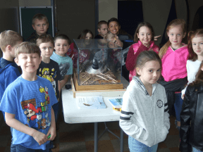
Since 2006, FOWL has sponsored a yearly loon education program for all 3rd graders at the Academy Hill School in Wilton, where they learn about loons, loon habits and habitats, and loon safety. The family of Wayne Smith provides a generous yearly donation to help fund the program. Loon experts from Biodiversity Research Institute in Portland come and talk about loons, present a loon slide show, and discuss a stuffed loon that accompanies them. Students and teachers love the program!
David Prince Memorial Fund
The David Prince Memorial Scholarship, begun in 2004, is a yearly award given to a graduating MT Blue HS senior who is pursuing higher education. It is based on scholarship, community service, extracurricular activities, and work history. Preference is given to students who are Wilton residents, have attended Wilton schools, or have a connection to Wilson Lake. Special consideration is given to those with a special interest in environmental science, biology, or education. The awardee is given a personal plaque, and their name is added to the large scholarship plaque at the high school, which lists all the winners.
Annual Audubon Loon Count
Each year on the 3rd Saturday of July, over 1,000 volunteers take part in the Maine Audubon loon count where they venture onto lakes and ponds around the state and count the number of adult and chick loons on their lakes. They go out at 7:00 am, and finish at 7:30 am. Our loon counter on Wilson Lake is Judy Landry, who together with her husband Dennis, have been doing this for 15 years. Eight adults and three chicks were spotted in 2021.
Courtesy Boat Inspection (CBI) Program
The CBI program was started on Wilson Lake in 2003, where each summer weekend boats entering and leaving the lake are inspected for invasive plants. To date Wilson Lake remains free of invasives. A record 1065 boats were inspected in 2020. Community business partners sponsor inspection weekends and a poster advertising their services is displayed in the FOWL kiosk at the boat ramp. Over 13,000 boats have been inspected since the program’s inception.
Blueberry Festival Boat Rides
FOWL offers free boat rides around the lake to Blueberry Festival attendees. 240 riders were served in 2019.
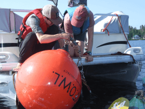
Water Testing on Wilson Lake
We employ various means of testing the water quality and water clarity of Wilson Lake, including Secchi disk readings, and readings for dissolved oxygen, temperature, and phosphorous levels. A unique program is a joint research project between FOWL and the University of Maine Farmington. The lead professors are JuIia Daly and Rachel Hovel, who coordinate the project with their students. A large red buoy sits at the “deep hole” with an 80 foot line suspended from it that includes temperature and dissolved oxygen sensors at various levels. They periodically pull up the line to download the data. Another unique feature is that it records data year-round. Periodic detailed reports can be found in our Newsletters on our website.
Report of Strategic Planning – Shaping the Future of FOWL
Under the capable facilitation of Jen Jespersen of Ecological Instincts, FOWL underwent a strategic planning process late 2020, early 2021, that resulted in the document, “Shaping the Future of FOWL: A Planning Strategy for 2021-2025.” Three broad categories were identified: Board and Membership Development; Public Relations-Outreach; and Lake Science, along with Administration. It can be seen on our website.
AVCOG Environmental Achievement Award
In May 2021, the Town of Wilton and FOWL were honored with an “Environmental Achievement Award” from the Androscoggin Valley Council of Governments. With the Town, FOWL did a Watershed Survey in 2016, completed a Watershed Based Protection Plan in 2017, and received a 2018-2019 federal grant ($69,696) under the Clean Water Act 319 Nonpoint Source Management Program to target runoff, support public and school children education programs, and provide LakeSmart evaluations and certifications. We very much appreciate the award and feel it is a testament to the cooperation and good work that can come from local associations working with their local government.
Annual Meeting and Newsletter
FOWL provides its members with a newsletter three times a year, and the Annual Meeting is held in July.
Mary Ryan -- Volunteer Extraordinaire
The well-being of our lakes depends to a great extent on the work of dedicated volunteers and Wilson Lake is very fortunate to have Mary Ryan serving in that role. At the 2021 Lake Stewards of Maine annual meeting Mary was recognized for 35 years as a lake monitor. According to Roberta Hill, this many years of service puts her “in a very elite group of uber-dedicated volunteers”; it places her in the top 1% of the hundreds of volunteers who have ever served.
May 2021: Coffee Pond (Cumberland County)

Image credit: Kim Bennett
About Coffee Pond
The Basics...
Coffee Pond is located in the town of Casco, and is approximately 43 hectares (106 acres) in surface area. The lake has an average depth of 9.8 m (32’), a maximum depth of 21.3 m (70’), and it supports both warm and coldwater fisheries. Transparency measurements for the pond have been consistently deep with an 8.5 m (28’) historical average. Although its name implies darkly colored waters, the average color measurement for it is 9 SPU (Standard Platinum Cobalt Units), which is relatively low compared to other Maine lakes. The most recent invasive aquatic species survey -- a comprehensive level 3 that took place in 2014 -- found no invasive aquatic plants in the waterbody. The most recent Loon Survey (2020) recorded two adults and two chicks.
Gavia immer
The Common Loon (Gavia immer) is a medium-large aquatic bird, between 66-91 cm (26.0-35.8 in) and weighing between 2.5-6.1 kg (5.5-13.4 lbs) according to the Cornell Lab of Ornithography. They are known for their distinctive calls and, in the summer, the adults have striking red eyes and black bodies with white dappling and pinstripes. They are a diving species with an elongated, pointed bill (beak) that is diamond-like in cross section. Their elongated bodies are hydrodynamic and their webbed feet stick out beyond their tail allowing them to propel themselves efficiently through the water. These elongated bodies and their powerful wings also make them exceptional fliers; they have been recorded at traveling at speeds of over 120 km/h (75 mph).

Loons on Coffee Pond, photo by Kim Bennett aka MaineKayakGirl of the Kayaking In Maine blog
This flight speed serves them well as they have been known to migrate over 2,500 km (1,553 miles), northward in spring to locations that include Maine lakes, where they nest and typically raise 1-2 chicks. Toward the end of summer and early fall, they begin their southerly journey to winter habitat. Loon parents raise their chicks together for approximately 12 weeks, before leaving their offspring and flying separately to different warmer coastal areas. They usually reunite as a pair the following spring. Juveniles also migrate southward that first year, but will remain along the coast for several years until they are ready to return to a lake environment for breeding.
Maine Audubon has run an Annual Loon Count community science program since 1984. An article about the program in 2020 can be found HERE. The Lakes of Maine website has a data visualization of the loon count data HERE.
Please note: Gavia immer is not the only loon species we have in Maine. The Red-throated Loon (Gavia stellata) is a coastal species, but can be seen on Maine lakes during migration. It breeds in Northern Canada, Iceland, Greenland, and Russia.
Learn more about Coffee Pond HERE, or check out conservation areas near it HERE. You can also find an excellent guide for non-motorized watercraft recreation HERE or if you prefer a paper version, check out her guidebook: Paddling Southern Maine.

April 2021: Big Lake (Washington County)

Image credit: Madeline Moore
About Big Lake
The Basics...
Big Lake is located in Washington County, and at approximately 4,227 hectares (10,444 acres) in size, is one of the largest lakes in Maine. It supports both warm and coldwater fisheries. The waterbody feeds into the west branch of the Saint Croix River (formerly and also known as the Passamaquoddy River) after passing through Long Lake, Lewy Lake, and the Grand Falls Flowage. The Passamaquoddy Tribe at Indian Township owns land that is located along the shores of Big Lake and is a substantial landholder in that area. In the autumn of 2019, the lake was confirmed to be infested with variable water-milfoil (Myriophyllum heterophyllum). Big Lake is largely littoral with an average depth of 3.66 meters (12 feet), making the surveying of all potential habitat for the invasive plant a significant undertaking. Lake Stewards of Maine is working with the Passamaquoddy Tribe, Downeast Lakes Landtrust, Big Lake Milfoil Coalition, Maine DEP, local guides, businesses and residents, and a large and growing team of LSM Invasive Plant Patrollers to complete a comprehensive (Level 3) survey of the lake this summer (2021) to determine the full extent of the Big Lake infestation.
Myriophyllum heterophyllum
Photo credit: Dennis Roberge
Variable water-milfoil (M. heterophyllum) is the most abundant invasive aquatic plant in Maine. It is native to parts of the US but is not native to New England. Due to its prolific growth, ability to spread quickly, outcompete native aquatic plant species, and interfere with recreation, this plant is a serious threat to Maine lakes.
The first evidence of M. heterophyllum in Big Lake was found by Brad Richard -- a local warden and camp-owner -- in late September, 2019. To read further about the findings, please see our articles here and here. If you are interested in getting involved with this effort, please contact LSM Invasive Aquatic Species Director, Roberta Hill: roberta@lakestewardsme.org.
The Passamaquoddy

The Passamaquoddy are a group of American Indian or First Nations people located primarily in Maine and New Brunswick, Canada, and who trace their ancestry back 12,000+ years. The Passamaquoddy Tribe is represented by the Joint Tribal Council which consists of individual Tribal Councils, one from Indian Township, in Princeton, and one from the Pleasant Point Reservation (Sipayik) in Perry. The tribe is one of the native groups that constitute the Wabanaki Confederacy. The current Chief (or Sakom) of the Passamaquoddy is William J. Nicholas, Sr. The Passamaquoddy who live to the north and east of the St. Croix (Passamaquoddy) River have their own chief and council and are known as the St. Croix/Schoodic Band of Passamaquoddies.
The tribe’s name, according to Vincent Erickson in his book American Indian Languages: The Historical Linguistics of Native America, is said to have developed from their word Peskotomuhkat. This translates to "pollock-spearer" or "those of the place where pollock are plentiful". This connection to a fish reflects the importance of water in their culture. Listed upon their website as one of the six mission tenants is “custodianship of our environment”. In 1993, the nation initiated its Water Resources Planning and Inventory Program. Joe Musante -- a biologist with the Passamaquoddy Environmental Department, LSM Regional Coordinator for the Passamaquoddy tribal lands, and member of LSM’s Board of Directors -- has been working with LSM and its partners in the logistics, surveying, identification, and removal of the invading M. heterophyllum.
Learn more about Big Lake HERE or check out conservation areas near it HERE
March 2021: Mill Pond
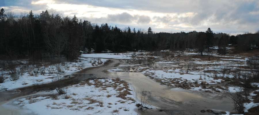
Image credit: Peter Taber
About Mill Pond
The Basics...
Mill Pond is a small waterbody located in Searsport. It is approximately 2 hectares (5 acres) in size and supports some warmwater fish species. It was historically a larger waterbody, but sediment deposition — in part, due to beaver dams slowing down the water — has transformed its northern end into marshland (as seen in photo by Peter Taber). It is a freshwater system although it is located only 9 m (29.5’) above sea level and in close proximity to the ocean. A significant reason for this is the small impoundment, which State of Maine records indicate was constructed in 1900 and is owned by the Town of Searsport. The impoundment is ~4.9 m (16’) high and has a ~4.3 m (14’) hydraulic height. This substantially separates the pond from the tidal cycles that could result in a saltwater intrusion, which, in turn, could dramatically change the water quality and habitat of the waterbody. While the processes of gradual sediment deposition and beavers damming at the northern end can be considered natural eutrophication, human manipulation of the environment is also at play here, even in the possibility of Mill Pond as an existent pond and not a saltwater marsh. The issues associated with impoundments, and of their removal are often complex and require significant understanding of the changes that could occur to an ecosystem, both what is gained and what is lost.
Eutrophication: Cultural vs Natural
Often eutrophication is viewed as a harmful and unnatural process. This process needs an adjective in front of it though to describe what type of eutrophication is or has taken place: cultural or natural. A fundamental difference between these two is the element of time.- Natural eutrophication is a process that occurs over historical or geologic time, due to normal rates of erosion and sediment deposition, the gradual accumulation of organic matter in the system, and associated enrichment with nutrients from these. Changes in hydrology, caused by major storm events, impounded areas created by beavers (Castor canadensis), and other natural factors can also shape this process, leading to the creation of wetlands. Freshwater ponds and their associated wetlands here in Maine provide excellent habitat for a wide range of flora and fauna including beaver, muskrat, waterfowl, raptors, turtles, and amphibians. Naturally eutrophic ponds usually achieve a state of ecological balance over time. While planktonic algae and rooted aquatic plants are typically plentiful and essential to the food web, problematic algal blooms are less likely to occur.
- Cultural eutrophication is the acceleration of the nutrient and sediment enrichment process, as a result of human activities in an aquatic system. The cumulative effect of enriched stormwater runoff from disturbances in a watershed can result in an imbalance, leading to excess algae growth, dissolved oxygen loss, and an overall loss of species diversity - all indicators of an unhealthy aquatic system.
Learn more about Mill Pond HERE or check out conservation areas near it HERE

February 2021: Nickerson Lake

Image credit: Ruba Haddard
About Nickerson Lake
The Basics...
Nickerson Lake is a crescent shaped lake with its bowl facing south. It is located in the towns of Linneus and New Limerick, in Aroostook county. At 98.3 hectares (243 acres) it is the second largest lake in the Meduxnekeag River watershed. The lake is moderately deep with a maximum depth of 32.6 meters (107 feet) and an average depth of 10.4 meters (34 feet). This enhances the lake’s ability to support a coldwater fishery, along with the cold temperatures in Aroostook, and its ability to retain sufficient dissolved oxygen in the warm summer months. On April 22, 2018, Al Cowperthwaite (Nickerson Lake resident), measured the ice in front of his home to be 26" thick, other places in the lake were a little more than a slushy scum! Nickerson Lake has an average Secchi transparency depth of 8.8 meters. The lake is also interesting in that it is on the upper range of Maine lakes for conductivity, pH, and total alkalinity, 126 uS, 7.9, and 63.9 mg/L, respectively.
Nickerson Lake Wilderness Preservation, Inc.
Nickerson Lake boasts a truly valuable resource, its own wilderness preserve. In 1983, a parcel of 26.4 hectares (90 acres) of forested land and 1.6 km (1 mile) of lakeshore was donated by James Pierce, on condition that it should be kept “forever wild”. This parcel under the management of Nickerson Lake Wilderness Preservation, Inc., has grown to approximately 94.3 hectares (233 acres), of which 2.8 km (1.75 miles) is lakeshore. The preserve is situated to the south of the lake, and encompassing the greater portion of the southern shoreline.
Nickerson Lake Wilderness Preservation, Inc., is a very active conservation group. Its by-laws were expanded to also protect the water quality in Nickerson Lake, and the forested land of the preserve is undoubtedly a significant component to its good water quality. The Nickerson Lake community has a website and a Facebook page. The Nickerson Lake Conservation Fund -- a subsidiary organization -- has recently put together a photo submission contest for their 2020 photo poster as a means of fundraising.
The geomorphology of Nickerson Lake
You may notice that Nickerson Lake has an unusual shape. Shaped much like a single parenthesis opening to the south, the lake is an irregularity compared to the outline of many other lakes in Maine. Smaller lakes sometimes have this sort of appearance. These are usually formed by fluvial geomorphic processes in which sections of the river become closed-off to create the standing waterbody; these are commonly known as oxbow lakes. But that is not the case with Nickerson. Instead, the cause of Nickerson’s shape is glaciation.
The glaciers that once covered all of Maine scraped off the sediments and wore down the bedrock. Nickerson is situated at the nexus of the Carys Mills formation and a Devonian intrusion. The Cary Mills formation is stratified rock (meaning laid down in successive layers) of interbedded pelite and limestone and/or dolostone from between 490 and 443 million years ago. The Devonian intrusion is granite that broke through the Cary Mills formation between 419 and 359 million years ago. Granite is a much harder stone than pelite, limestones, and dolostones. As the softer bedrock was carved away by the glaciers, more of the granite intrusion remained and a letter cee with its mouth open to the south was formed as the glaciers retreated; this is what gives Nickerson its shape. As a last interesting tidbit, this granite is part of the same volcanic activity that formed Mount Katahdin in Baxter State Park.
You can see Maine’s Bedrock Geologic map HERE and find additional resources for understanding geologic maps on the State of Maine Geologic Survey website and the University of Madison Wisconsin geology website.
Learn more about Nickerson Lake HERE or check out conservation areas near it HERE

January 2021: Sebago Lake

Image credit: Camilla Fecteau Bridge, taken at St. Joseph's College, Standish
About Sebago Lake
- Sebago Lake is located in the towns of Casco, Naples, Raymond, Sebago, Standish and Windham. It is the deepest and second-largest lake in Maine at 96.3 meters (316 feet) and 12,137 hectares (29,992 acres), respectively. The perimeter of Sebago -- 158 kilometers (98.2 miles) -- is substantially developed and about 90% of the watershed is privately owned. Despite this, significant eutrophication (caused primarily by phosphorus runoff) has been limited. This is vitally important as it is the primary water supply for the Portland Water District (PWD) which serves nearly 15% of Maine’s population. The reason for the limited eutrophication is due to the large and heavily-forested nature of the watershed and the fantastic work of PWD, Sebago Clean Waters, and many lake stewards. Two other factors that may play a role are that areas of its watershed -- notably the Long Lake region -- are naturally high in aluminum and are at greater elevation. Generally, higher elevations have less marine-derived clay soils which are typically high in phosphorus. A last note, the oldest recorded ice-out, taken in 1807 CE, comes from Sebago.
- The state of ice coverage on Maine lakes has become an increasingly prominent concern. It appears, based on ice-out data, that over the past 100 years there has been a substantial shift towards earlier ice-outs. This means it is likely that ice is covering lakes for less of the year. Extended periods of ice cover is one of the reasons why Maine has such high quality lakes compared to many other parts of the United States. Blooms of cyanobacteria and algae, and certain invasive species are all tempered or prevented from establishing due to the long, cold winters.
To discuss ice further we need to understand the terminology and complications of monitoring it. Both ice-in and ice-out are localized events defined by the observers. At Lake Stewards of Maine (LSM), we have provided some guidelines that individuals or lake associations can use. However, if there are historical observations, the observers should maintain that same criteria for determining these events. The consistency is vitally important to pick up on changes over time.
The monitoring by our citizen scientist network remains a critical component for understanding our lakes. In the mid-2000s, using data, including that collected by LSM volunteers, USGS Hydrologist Glenn Hodgkins was able to determine that the duration of ice cover for a number of New England lakes has been diminishing over the past century. This same conclusion has been arrived at by Lloyd Irland, PhD. This past summer LSM hosted Dr. Irland as a part of our summer webinar series. A recording of the session, Lake Ice Regimes: Some Baffling Trends and Challenges for Citizen Science, can be found HERE.
Charts by Lloyd C. Irland, from research now being prepared for publication.
Both ice-in and ice-out are really proxies for climate change and variations between seasons. The charts of average ice-out dates (above) show the movement towards an earlier ice-out, indicated by the negative slope of these two trend lines. One of the important take-aways is that there is significant variation between the years and even decades. It is only with long-term data sets that trends can be identified. Ice-out has a more robust historical record in many communities -- this may be due to the celebratory nature of warming weather and the autumn harvests and preparing for the colder months ahead. Although ice-in data is patchy and does not have as long a history as ice-out data, what is available indicates ice-in dates are becoming later. This double-sided attack -- later icing over in the fall and earlier retreat of ice in the spring -- is another troubling indicator of climate change and a warming Maine, more prone to algae blooms and invasive organisms.
If you’re interested in getting involved in ice data collection please check out the information available on our website and contact us HERE.
Learn more about Sebago Lake HERE or check out conservation areas near it HERE
December 2020: Bartlett Pond Lake (Androscoggin County)

Image credit: Jonnie Maloney
About Bartlett Pond:
- Bartlett Pond is located in Livermore. It is a relatively small pond with an area of about 11.3 hectares. It is also relatively shallow with a mean depth of only 3.7 meters. Maine Inland Fisheries and Wildlife has classified it as supporting cold water fisheries and as far as we know there are no invasive species present. Sadly though, there is little data available beyond this about Bartlett Pond. This is one of many lakes in Maine that do not or have not had a water quality monitor and/or invasive plant patroller. If you want to get involved in monitoring lakes, you can contact Lake Stewards of Maine (LSM) HERE.
- In the early 1800’s a new form of industry was established: ice harvesting. Fredric Tudor of Boston began shipping ice from cold regions to warmer regions like the southern United States and Caribbean. Although the ice trade was not new (wealthy families often had icehouses), Tudor revolutionized it by creating specially-designed cargo holds on ships that kept the ice cold long enough to get to their destination.
Prior to Tudor’s innovation, ice harvesting was dependent on local resources. According to Eric Cline, PhD., some of the earliest evidence for ice harvesting and storage comes from the Bronze Age (circa 1750 B.C.E.) in Mesopotamia. Special buildings were needed to keep ice harvested in winter (or from glaciers at high elevations) cool in the summer months. As metropolitan areas expanded, ice also became desirable in these urban heat islands (e.g. New York and Philadelphia) during summer months. It was this latent desire, a murderous heat wave in 1896, and varied forms of shipping that Tudor, Charles Morse of Maine, and others leveraged to grow their businesses beyond simply sales in the South.
In Maine, the harvest and sale of ice became a major source of revenue. Morse’s work was a significant portion of this. He was well-positioned, having inherited his father’s towing business along the Kennebec River. According to historical maps from one Boston ice broker, in 1882 1.5 million tons of ice were harvested from the fresh waters of Maine. Between 1870-1890, over 25,000 people were employed each winter to cut and store ice. Due to Maine’s high water quality and cold winters, the ice of Maine became the national standard for quality and was noted upon for its crystal-blue color. In addition, sawdust from Maine’s lumber industry was collected and used both as insulation for Maine’s ice and as a commodity for other ice shipping. The wealth produced from these ice harvests was greater than California’s annual gold production.
Early on Tudor, who controlled the majority of ice shipping, would sell ice at a loss in order to drive out competition in a particular region. This behavior suddenly made ice available to the average person, increasing market demand and leading to changes in food preservation, notably the development of the household ice chest. Morse, coming some 70 years later, sold stock in his ice company and expanded his business. In a ploy to create a monopoly and manipulate the price of ice, driving it higher, Morse failed. The corruption was revealed by the New York Journal and Advertiser, however Morse was able to leave the ice trade with an estimated $12 million in profits. Morse’s timing turned out to be good, by the early 1900s the invention of mechanical cooling and fears over typhoid and pollution caused a significant downturn in the purchasing of natural ice. Today, ice harvesting is no longer a commercial venture but has remained as a component of historical reenactments and occasionally for use in ice sculptures.
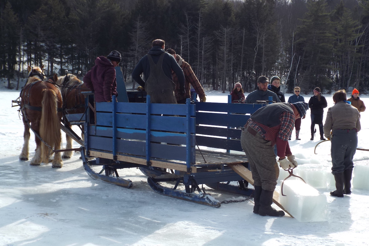
Image credit: Washburn-Norlands Living History Center
Organizations like, The Washburn-Norlands Living History Center, a museum located in Livermore, Maine, hold ice-centric activities to relieve the stress of winter and to highlight the significance of ice harvests in Maine’s history. Washburn-Norlands Center’s Cabin Fever Reliever event is located on Bartlett Pond, however due to CoViD-19 they are likely to forego the 2021 event. More information about their past event can be found HERE; more information about Maine’s history can be found at the Maine Historical Society website.
Learn more about Bartlett Pond HERE or check out conservation areas near it HERE

November 2020: Androscoggin Lake (Androscoggin County)

Image credit: Martha Hoddinott [edited]
About Androscoggin Lake:
- Androscoggin Lake is located in western Maine and split between the towns of Leeds and Wayne. It is part of the 30 Mile River watershed and connected to a number of other water bodies including Bonny Pond, Pocasset Lake, Lovejoy Pond, Echo Lake (Crotched Pond), and the Androscoggin River. The lake supports both cold and warmwater fisheries, has a maximum depth of 11.6 meters, and an average transparency of 4.3 meters.
- Another connected waterbody is the Dead River (Androscoggin county). This boggy river is known to reverse its flow during times of high runoff and may inject humic acid, potential contaminants, and sediments into the lake. This may lead the lake to experience greater variability in color and additional complications such influxes could produce.
- According to the Maine Natural Areas Program, Androscoggin Lake is one of the only known locations in Maine where the rare plant, cattail sedge, Carex typhina, can be found. Maine is the northern limit for this species’ range; the range covers part of Maine and southwest Quebec, runs westward to Wisconsin, south to Louisiana, and east to Georgia, then back up the eastern seaboard. It is possible with warming, due to climate change, that the range will extend further north. More about the C. typhina and both native and invasive plants in Maine can be found HERE.
- In the late summer of this year, 2020, variable water-milifoil, Myriophyllum heterophyllum, was found in Androscoggin Lake by Katherine Mahoney, a member of Androscoggin Lake’s Invasive Plant Patrol team. The suspicious plant was found in Inner Cove, at the northern end of the lake, about 400 yards northwest of the state boat launch. The plant that was found lacked the features needed to confirm an identification with 100% certainty, so the specimen was sent on to Dr. Lucas Bernacki of Saint Joseph’s College for DNA analysis. Upon learning the DNA results, which unfortunately confirmed the invasive species, a coalition of local, regional and statewide partners including 30 Mile River Watershed Association (30 MRWA), Androscoggin Lake Improvement Corporation, Lake Stewards of Maine (LSM), and Department of Environmental Protection (ME DEP), leapt into action.
On the 3rd of October, 2020, Roberta Hill of LSM and Lidie Robbins of 30 MRWA led a team of 15 volunteer invasive plant patrollers (IPPers) in screening surveys of the lake with the focus upon Inner Cove, where that first specimen was found. Several patches of variable milfoil were found; one patch, more than 10 feet in diameter, suggested that the milfoil has been present in the cove for at least a year. On October 15th, another screening was conducted, this time assisted by several of LSM’s Uber-IPPers and two divers, one from the ME DEP and one from Little Sebago’s milfoil removal team. Four additional plant clusters were identified. Invasive plants were removed from all identified locations.
M. heterophyllum spreads through two mechanisms: auto-fragmentation and vegetative propagation. The parent plant becomes more brittle toward the end of the growing season, and breaks apart (auto-fragmentation), creating numerous viable fragments. Each fragment is a clone of the parent plant and mobile. When caught in a current, or by the wind, or even something like a boat’s line they are carried off to a new location. If they come to rest in a good spot, through the action known as vegetative propagation, the fragments will sprout roots, and may establish a new colony.
The fact that (so far) the M. heterophyllum seems to be confined to the wetland at the northwestern corner of Inner Cove, provides some hope that the infestation may have been caught early on. In order to be sure, LSM, our volunteers, and partner organizations need to conduct a comprehensive (Level-3) survey of the entire littoral zone of the lake. Thanks to the efforts and dedication of the various partners and IPPers, plans are already underway to ensure such a survey will be completed next summer. If you are interested in getting involved, please contact Roberta at roberta@lakestewardsme.org.
Learn more about Androscoggin Lake HERE or check out conservation areas near it HERE.

October 2020: Big Reed Pond (Piscataquis County)

Image credit: Bill Silliker, The Nature Conservancy
About Big Reed Pond:
- The Nature Conservancy’s Tim Paul writes about Big Reed...
Big Reed Pond lies north of Baxter State Park in T8R10 within The Nature Conservancy’s 4,583-acre Big Reed Forest Reserve, the largest and most outstanding old‑growth forest in New England. The property is managed as an ecological reserve, where the forest and waters are shaped by natural processes such as wind, ice, and other weather events. Beyond providing valuable natural habitat, ecological reserves are important to scientists studying the forest ecosystem and how it responds, in the absence of timber harvesting, roads and other human intrusion, to challenges such as climate change, forest pests, diseases, and airborne pollution.
- There are three ponds within the preserve and at 90 acres, Big Reed Pond is the largest. Big Reed Pond contains one of the few remaining populations of landlocked Arctic charr (Salvelinus alpinus oquassa) in the eastern United States. Arctic charr once inhabited lakes across the northeastern United States and Canada. However, because it is very susceptible to environmental change, the introduction of non-native fish species and pollution has led to the extirpation of native U.S. populations of charr in all but Maine and Alaska. Eleven lakes in Maine have native Arctic charr populations. (The other 2 ponds in the preserve are Little Reed and Buckley.)
- While surveys of the Arctic charr in the 1980s indicated that the population was stable, fishing success rates dropped precipitously in the 2000s, signaling poor reproductive and survival success in Big Reed charr. The introduction of rainbow smelt, likely by the illegal dumping of bait, altered the dynamics of the pond as smelt aggressively feed on charr eggs and fry. In 2008, the Maine Department of Inland Fisheries and Wildlife began removing charr and brook trout from the pond to a hatchery in order to chemically destroy the invasive smelt. After reclamation of the pond in 2010, progeny of the original charr were restocked in the pond and by 2017 biologists confirmed that natural reproduction of the fish was once again taking place in Big Reed and the population was rebounding. The pond also sustains a diverse population of native brook trout and minnows.
- Big Reed Pond is only accessible by float plane or hiking in through the remarkable old growth forest, therefore it receives little visitation or fishing pressure. As a consequence it provides a unique wilderness lake experience. Overnight camping or fires in the reserve are not allowed.
- Explore the various conservation areas in the Big Reed area HERE.

September 2020: Eastern painted turtles, Lake Auburn area

Credit: R. Crosby
About Lake Auburn:
- The Eastern painted turtle (Chrysemys picta picta) is one of 7 turtle species in Maine. In the early 2000s, The Nature Conservancy led a major synthesis study of Maine's freshwater biodiversity. The study's final report contains a wealth of information about aquatic biodiversity in Maine. Chapter 6.3 focuses on amphibians & reptiles - and includes species distribution maps.
- Lake Auburn (which used to be called Wilson Lake) is the municipal water supply for the cities of Auburn and Lewiston. Lakes Stewards of Maine's Scott Williams takes up the story of this lake...
- Historically, this lake has experienced very good water quality, as evidenced in part by the fact that it supports a healthy coldwater fishery (primarily Lake Trout). At one time, Lake Auburn was a popular destination for visitors from around the globe, who would board the "Steamship Lewiston" Ferry on the easterly side of the lake at "Lake Grove Resort" en route to the westerly shore, where a world-famous grand hotel and mineral spring spa was highly valued by those who drank and bathed in its reportedly restorative waters. The hotel famously burned in the late 1800's.
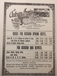
- For more than a century, the municipal water district and the Lake Auburn Watershed Protection Commission have worked diligently to protect the health of this lake through educating landowners about lake conservation practices, purchasing conservation easements throughout the watershed and virtually eliminating all shoreline development. But in 2012, Lake Auburn experienced an unanticipated severe algal (cyanobacteria) bloom, resulting in a significant die-off of the Lake Trout population, less than 2 meters water clarity, and high concentrations of phosphorus. The Auburn Water District convened a group of lake researchers who, over a period of a few years, unraveled the complex factors that led to this phenomenon. Climate warming, extreme weather events, lake sediment geochemistry and other factors combined to create the "perfect storm" that caused the bloom. In 2019, a successful "alum" treatment was conducted on the lake. Water clarity (Secchi transparency) readings in 2020 have been as high as 12 meters!
Discover more about Lake Auburn HERE.

August 2020: Flanders Pond (Hancock County)

Credit: Roberta Hill
About Flanders Pond:
- One of nine lakes & ponds in the town of Sullivan, 535-acre Flanders Pond lies just off of the Downeast Sunrise trail which runs from Ellsworth to Ayers Junction along a portion of the route of the former Brewer-Calais railroad. This section of the trail provides access to hiking trails up Schoodic Mountain.
- Flanders Stream, on the southwest corner of the lake, is well known locally for its large alewife run. There is an alewife viewing area on Thorne Road (just off of Route 183) and the fish can often be seen spawning around the edges of the lake's several islands.
- Maine Audubon's annual loon surveys on Flanders Pond have been taking place since 1987.
- The banner photo (above) is of an LSM "Plant Paddle" held on Flanders Pond in 2017. The event brought together volunteers from across the region to learn how to work as a team to conduct an invasive aquatic plant (IAP) screening survey. It is likely that most of the records in our list of 13+ aquatic plants recorded from this lake come from this plant paddle.
- There are currently over 80 Invasive Plant Patrol (IPPer) teams conducting screening surveys across the state of Maine. Most teams conduct Level-3 surveys annually. In a Level-3 survey, the entire littoral zone (the shallower portions of the lake that support rooted aquatic plant life) is screened for the presence of aquatic invaders. In many cases, IPPers also document the native aquatic plants observed during the course of the survey. In this way, LSM citizen lake scientists are not only helping to detect aquatic invaders early, before they become well-established, they are also helping us to better understand Maine's native plant communities.
- Plant paddles are short (2-3 hour) events that take place on shore and on the water. They are a fun and informal way to introduce community members to the threats of invasive aquatic plants and ways to minimize their impacts through early detection. You too can become an IPPer! The work is not only interesting and important, it is great fun! To learn how you can get involved, please click HERE
- You can find a wealth of information on invasive aquatic plants by clicking HERE and by clicking HERE.
- Discover more about Flanders Pond HERE.

July 2020: Coleman Pond (Waldo County)
Credit: Deborah Fink
About Coleman Pond:
- 255-acre Coleman Pond in Lincolnville has a maximum depth of 13.4m (44ft) and average Secchi depth of 4.7m (15.4ft).
- The invasive Northern pike (Esox lucius) is one of at least 16 fish species in this lake.
- WATCH:
- An aerial & surface video tour of Coleman Pond and neighboring Pitcher Pond.
- Alewife stocking in 2016. (Both videos courtesy of Lincolnville Lakes & Ponds Committee)
- Along with other lakes and pond communities in the town of Lincolnville, Coleman Pond is working to address what has become an insidious threat to lake ecosystems across the state. The Lincolnville Lakes & Ponds Committee (LLPC) and the Lincolnville Board of Selectmen have recently adopted a program to help lakeshore property owners transition away from the use of unencapsulated polystyrene floats (the commonly-blue Styrofoam panels used to keep docks and rafts afloat). Over time, the polystyrene has a tendency to break down, distributing a seemingly infinite number of tiny light-blue bead-like pellets into the water column where they may be mistaken as food by a wide host of lake dwellers, causing disruption to the natural food web.
- The LLPC program is strictly optional and involves volunteers from each of the lakes and ponds in the town (including Coleman Pond) conducting annual dock/float surveys. Surveyors simply record the number of unencapsulated floats currently in use on the lake. LLPC publicizes the results of the annual surveys while encouraging lakefront owners to make the conversion to more environmentally friendly forms of floatation. A group of LLPC community members have created a fund to help lower income families to make the conversion; other community members have offered their time and skills, providing assistance to those who cannot make the conversions themselves. The number of unencapsulated floats on Lincolnville lakes has gone down steadily since the program was adopted.
- More info on upgrading dock floats is HERE.

June 2020: Cross Lake (Aroostook County)
Credit: Friends of Cross Lake
About Cross Lake:
- One of Maine's most northerly lakes, 2,537-acre Cross Lake lies approximately 15 miles south of the Canadian border. It is the third lake in the east branch of the Fish River Chain of Lakes. It is typically iced-in from the first week in December to the first week in May.
- Cross Lake and its watershed provide excellent year-round recreational opportunities. Besides the approximately 260 shorefront properties, a large public boat landing and picnic area allow visitors to enjoy the lake and it also provides access to Square Lake, with its excellent coldwater fishery, both for open water fishing and ice fishing.
- Cross Lake also supports a sport fishery of statewide significance for native brook trout and landlocked salmon and has been identified as a Wild Brook Trout Water, meaning it has self-sustaining populations of native brook trout.
- In 2018, the Friends of Cross Lake (FOCL) was started by locals to spearhead efforts to improve and protect Cross Lake's water quality, which is classified as impaired due to excess phosphorus and low water clarity readings. FOCL has over 130 supporting members.
- In 2019, FOCL completed a watershed survey with 35 volunteers, the help of many partners, and a grant from LSM. In order to improve understanding of the dynamics of Cross Lake's water quality and to gather high-density data, 13 "Secchi Blitz" volunteers were also trained and certified by LSM and DEP to conduct biweekly monitoring of 12 stations around the lake. Two of those stations were also sampled biweekly for phosphorus and chlorophyll. Other 2019 activities that FOCL either led or assisted with included: a bathymetric survey by EPA, stream and wetland sampling by DEP, a gravel road workshop with the State Soil Scientist, and a LakeSmart program for shorefront property owners.
- In 2019, FOCL also received a DEP/EPA grant to develop a Watershed-Based Management Plan (WBMP) and the Cross Lake Watershed was chosen as an USDA NRCS National Water Quality Initiative (NWQI) project, providing additional funding and technical assistance to farmers in the watershed for conservation practices that protect water quality.
- FOCL is continuing its water quality improvement efforts with another year of gathering "Secchi Blitz" data, expanding LakeSmart, participating in Maine Audubon's Loon Count for the first time, and WBMP development, which will describe the actions needed to restore Cross Lake to meet water quality standards over the next 10 years
- Discover more about Cross Lake HERE

May 2020: Enchanted Pond (Somerset County)
Credit: D. Savage
About Enchanted Pond:
- Located in the mountains of western Maine, 334-acre Enchanted Pond is one of our state's most pristine lakes.
- With a maximum depth of 185 feet, it is also the 6th deepest lake in Maine - notably deep when Enchanted's relatively small surface area is considered.
- A factsheet How Deep are Maine Lakes? is HERE.
- Enchanted Pond is one of only 14 lakes in Maine to have a population of Arctic Charr (in this case, introduced from Floods Pond in Otis).
- The lake also has a "heritage" population of Brook Trout (there has been no stocking of this species since the early 1990s).
- Bulldog Camps is one of the oldest traditional sporting camps in Maine and is located on the northern end of the lake. Established in the 1880s as a set of logging camps, this property has been operating as a sporting camp since the turn of the last century.
- Discover more about Enchanted Pond HERE

April 2020: Clary Lake (Lincoln County)

Credit: D. Hodsdon
About Clary Lake:
- Located in the towns of Jefferson & Whitefield, 674-acre Clary Lake (also known as Pleasant Lake) is part of the Sheepscot River watershed. The lake is quite shallow, with a maximum depth of 30 feet (9.1 meters).
- Ice-out this year was on March 27, according to David Hodsdon of the Clary Lake Association.
- The water level of Clary Lake is maintained by a dam at its outlet on Route 218 in Whitefield. In 2014 a water-level order was issued by Maine DEP but the then-dam owner refused to comply with or maintain the dam and caused the lake level to be drawn down to a level lower than most people can remember, according to George Fergusson of CLA.
- After a 7-year negotiation, the Clary Lake Association was finally able to purchase the dam in October 2018. The Association promptly repaired the dam and has restored Clary Lake to its historical water level. A full recovery is expected.
- The Clary Lake Association has been engaged in water quality monitoring on Clary Lake since 1975. Today, 4 LSM certified water quality monitors measure transparency and dissolved oxygen twice a month throughout the boating season. The Association also runs a Courtesy Boat Inspection program at the State boat launch throughout the summer months.
- Discover more about Clary Lake HERE

February-March 2020: Ellis Pond (Oxford County)

Credit: Ross Swain
About Ellis Pond:
- Located in the towns of Byron and Roxbury, 919-acre Ellis Pond (also known as Roxbury Pond & Silver Lake) has a maximum depth of 43 feet
- Water clarity has been measured here every year since 1990 (with additional data from 1982).
- Lake stewardship is alive and well in the Ellis Pond community! The Silver Lake Camp Owners Association conducted two extensive citizen lake watershed surveys during the past two decades, each followed by mitigation projects, in which sources of runoff and erosion documented in the surveys were resolved. The Ellis Pond Sidekicks are also very active in lake stewardship. LSM Certified Lake Monitor, Ross Swain has been checking the health of the pond for 25 years. Recently, he documented the development of a brief, late season (October) algal bloom, which sometimes occurs when a lake "turns over" (de-stratifies or mixes). Such events may be an early warning sign that lake water quality is vulnerable to a change.
- Discover more about Ellis Pond HERE
January 2020: Branch Lake (Hancock County)

Credit: N. Norris
About Branch Lake:
- 2942-acre Branch Lake lies in the Union River watershed in Hancock County.
- This 124-ft-deep (38-m) lake is the public water source for the city of Ellsworth.
- Water clarity has been measured here since the early 1970s.
- Branch Lake is one of over 330 Maine lakes with records of ice-in / ice-out dates.
- Currently, LSM intern, Sarah Hammond is conducting a project in which she is surveying Maine's citizen lake scientists to learn more about changes in ice-in dates. To learn more about this project (and participate, if you wish), go HERE.

- Discover more about Branch Lake HERE
December 2019: Long Pond (Kennebec County)
Credit: P. Kallin
About Long Pond:
- There are 27 “Long Ponds” in Maine (and 6 “Long Lakes”). One of these is located in the Belgrade chain of lakes (it is fourth in the chain sequence)
- Long Pond (Belgrade, Mt. Vernon, Rome) is a 2,557-acre lake, divided into 2 distinct basins. The “deep hole” (106 ft / 32 m) is in the southern basin
- This lake has 20 fish species, including the invasive northern pike (Esox lucius), as well as both black basses
- The Kennebec Highlands (ME Bureau of Parks & Lands) lie to the west of the upper basin, while the Belgrade Regional Conservation Alliance manages lands along the southern basin (MAP)
- Water clarity has been measured in this lake since 1970; the overall average Secchi depth during this period is 6.3 m (21 ft) - a value which is in the mid-range of surveyed Maine lakes
- Discover more about Long Pond HERE
November 2019: West Pond (York County)
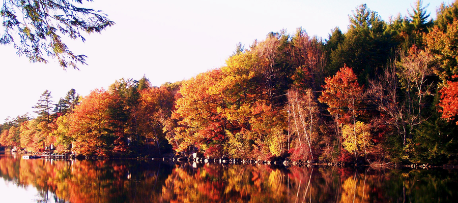
Credit: J. Howes
About West Pond:
- 167-acre West Pond is located in Parsonsfield. It is relatively shallow, with an average depth of 10 feet.
- Invasive curly-leaf pondweed (Potamogeton crispus) was confirmed to be growing in this lake in the spring of 2004. The key to getting ahead of this invader is to harvest it early in the season, before new winter buds, or turions, develop. (Once formed, each turion—which may remain dormant in the sediment for several years—is capable of sprouting a new plant.) With fifteen years of experience under their belts, much hard work and determination, and some help from the DEP and others, West Pond Association has succeeded in significantly decreasing the infestation, and remains fully committed to the effort. According to WPA President (and major force behind the control effort), Dennis Spinney, “we lost a bit of ground in 2019—likely due to an emergence of dormant turions—but we just doubled down on our control efforts and we are hopeful that this will pay off.”
- This is a warm-water fishery—including both largemouth and smallmouth bass, and black crappie.
- Discover more about West Pond here.
October 2019: Jordan Pond (Hancock County)

Credit: Joe Braun Photography
About Jordan Pond:
- 186-acre Jordan Pond is a lake of superlatives. Located in the heart of Acadia National Park, it surely is one of the most-visited lakes in Maine. Visually, it is also one of the most stunning of lakes
- On only 3 dates have measured water transparency (Secchi) values in any Maine lake exceeded 65 feet (20 meters) - all 3 dates are from Jordan P. (1991 and twice in 1999)
- The steep sides of this lake plunge down to a maximum depth of 150 feet
- The cold-water fishery focuses on Brook trout, Lake trout and Landlocked salmon - there are 10 other fish species and over 14 species of aquatic plants
- Discover more about Jordan Pond HERE